Lockport geodata
Lockport (Illinois) is a populated place; located in United States in America/Chicago (GMT-5) time zone. With population of 25,175 people, there are 1991 cities with bigger population in this country. Compared to other cities in United States, 71.7% of cities are located further ↓South; 53.1% of cities are located further →East and 53.9% of cities have higher elevation than Lockport. Note1


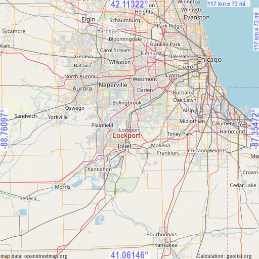
Lockport GPS coordinates[2]
41° 35' 22.128" North, 88° 3' 28.224" West
| Map corner | latitude | longitude |
|---|---|---|
| Upper-left | 42.11322°, | -88.76097° |
| Center: | 41.58948°, | -88.05784° |
| Lower-right: | 41.06146°, | -87.35472° |
| Map W x H: | 116.9×116.9 km | = 72.6×72.6mi |
| max Lat: | 71.29058° ⇑28.3% North |
| Lockport: | 41.58948° |
| min Lat: | ⇓71.7% South 19.06759° |
| min Long | Lockport | max Long |
| -171.73463° | -88.05784° | -66.98998° |
| W 46.9%⇐ | ⇒53.1% E |
Elevation
Elevation of Lockport is 184 m = 604 ft, and this is 110.8 m = 364 ft below average elevation for this country.
| Max E: |
3189 m = 10463 ft | 53.9% |
| Avg. | 294.8 m = 967 ft | |
| Lockport | 184 m = 604 ft | |
Min E: |
-60 m = -197 ft | 46.1% |
See also: United States elevation on elevation.city.
Geographical zone
Lockport is located in North temperate zone (between Tropic of Cancer and the Arctic Circle). Distance of this Northern Tropic circle is 2018.4 km =1254.2 mi to South.| Distance of | km | miles | from Lockport |
|---|---|---|---|
| North Pole | 5382.7 | 3344.7 | to North |
| Arctic Circle | 2776.9 | 1725.5 | to North |
| Tropic Cancer | 2018.4 | 1254.2 | to South |
| Equator | 4624.3 | 2873.4 | to South |


Nearby cities:
15 places around Lockport: (largest is in red/bold)
• Bolingbrook
12.2 km =7.6 mi,  355°
355°
• Crest Hill
5.1 km =3.2 mi,  221°
221°
• Crystal Lawns
8.6 km =5.3 mi,  255°
255°
• Fairmont
3.7 km =2.3 mi,  181°
181°
• Goodings Grove
11.4 km =7.1 mi,  67°
67°
• Homer Glen
10 km =6.2 mi,  83°
83°
• Ingalls Park
7.5 km =4.7 mi,  170°
170°
• Joliet
7.5 km =4.7 mi,  196°
196°
• Lemont
10.5 km =6.5 mi,  26°
26°
• New Lenox
11.5 km =7.1 mi,  138°
138°
• Plainfield
12.8 km =8 mi,  288°
288°
• Preston Heights
11.1 km =6.9 mi,  190°
190°
• Rockdale
10.4 km =6.5 mi,  206°
206°
• Romeoville
7 km =4.3 mi,  337°
337°
• Shorewood
14.2 km =8.8 mi,  237°
237°
Sources, notices
• [Note1] Compared only with cities in United States existing in our database
• [Src1] Map data: © OpenStreetMap contributors (CC-BY-SA)
• [Src2] Other city data from geonames.org with taken over terms of usage.
• [Src3] Geographical zone / Annual Mean Temperature by Robert A. Rohde @ Wikipedia
