Ottawa geodata
Ottawa (Illinois) is a seat of a second-order administrative division; located in United States in America/Chicago (GMT-5) time zone. With population of 18,342 people, there are 2734 cities with bigger population in this country. Compared to other cities in United States, 69.3% of cities are located further ↓South; 55.7% of cities are located further →East and 60.9% of cities have higher elevation than Ottawa. Note1


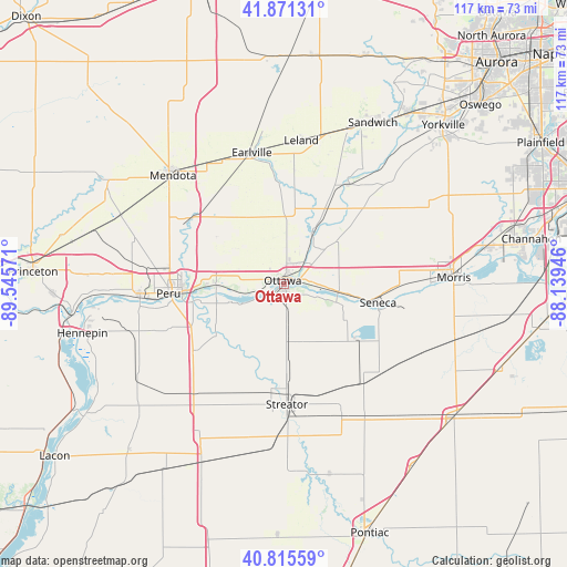
Ottawa GPS coordinates[2]
41° 20' 44.124" North, 88° 50' 33.288" West
| Map corner | latitude | longitude |
|---|---|---|
| Upper-left | 41.87131°, | -89.54571° |
| Center: | 41.34559°, | -88.84258° |
| Lower-right: | 40.81559°, | -88.13946° |
| Map W x H: | 117.4×117.4 km | = 72.9×72.9mi |
| max Lat: | 71.29058° ⇑30.7% North |
| Ottawa: | 41.34559° |
| min Lat: | ⇓69.3% South 19.06759° |
| min Long | Ottawa | max Long |
| -171.73463° | -88.84258° | -66.98998° |
| W 44.3%⇐ | ⇒55.7% E |
Elevation
Elevation of Ottawa is 150 m = 492 ft, and this is 144.8 m = 475 ft below average elevation for this country.
| Max E: |
3189 m = 10463 ft | 60.9% |
| Avg. | 294.8 m = 967 ft | |
| Ottawa | 150 m = 492 ft | |
Min E: |
-60 m = -197 ft | 39.1% |
See also: United States elevation on elevation.city.
Geographical zone
Ottawa is located in North temperate zone (between Tropic of Cancer and the Arctic Circle). Distance of this Northern Tropic circle is 1991.3 km =1237.3 mi to South.| Distance of | km | miles | from Ottawa |
|---|---|---|---|
| North Pole | 5409.9 | 3361.6 | to North |
| Arctic Circle | 2804 | 1742.3 | to North |
| Tropic Cancer | 1991.3 | 1237.3 | to South |
| Equator | 4597.2 | 2856.6 | to South |


Nearby cities:
15 places around Ottawa: (largest is in red/bold)
• Dalzell
27.9 km =17.3 mi,  272°
272°
• Dayton
5.9 km =3.7 mi,  42°
42°
• Deer Park
17.1 km =10.6 mi,  250°
250°
• Earlville
27.9 km =17.3 mi,  346°
346°
• Grand Ridge
12.1 km =7.5 mi,  175°
175°
• La Salle
20.8 km =12.9 mi, 266°
• Leland
29.9 km =18.6 mi,  6°
6°
• Marseilles
11.3 km =7 mi,  98°
98°
• Oglesby
19 km =11.8 mi, 252°
• Peru
24 km =14.9 mi, 265°
• Seneca
19.8 km =12.3 mi, 101°
• Sheridan
24.6 km =15.3 mi,  33°
33°
• Streator
25 km =15.5 mi, 178°
• Tonica
23.6 km =14.7 mi,  232°
232°
• Utica
14 km =8.7 mi, 267°
Sources, notices
• [Note1] Compared only with cities in United States existing in our database
• [Src1] Map data: © OpenStreetMap contributors (CC-BY-SA)
• [Src2] Other city data from geonames.org with taken over terms of usage.
• [Src3] Geographical zone / Annual Mean Temperature by Robert A. Rohde @ Wikipedia
