Streator geodata
Streator (Illinois) is a populated place; located in United States in America/Chicago (GMT-5) time zone. With population of 13,182 people, there are 3623 cities with bigger population in this country. Compared to other cities in United States, 67.1% of cities are located further ↓South; 55.7% of cities are located further →East and 51.6% of cities have higher elevation than Streator. Note1


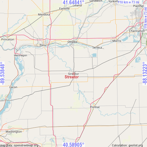
Streator GPS coordinates[2]
41° 7' 15.132" North, 88° 50' 7.26" West
| Map corner | latitude | longitude |
|---|---|---|
| Upper-left | 41.64841°, | -89.53848° |
| Center: | 41.12087°, | -88.83535° |
| Lower-right: | 40.58905°, | -88.13223° |
| Map W x H: | 117.8×117.8 km | = 73.2×73.2mi |
| max Lat: | 71.29058° ⇑32.9% North |
| Streator: | 41.12087° |
| min Lat: | ⇓67.1% South 19.06759° |
| min Long | Streator | max Long |
| -171.73463° | -88.83535° | -66.98998° |
| W 44.3%⇐ | ⇒55.7% E |
Elevation
Elevation of Streator is 192 m = 630 ft, and this is 102.8 m = 337 ft below average elevation for this country.
| Max E: |
3189 m = 10463 ft | 51.6% |
| Avg. | 294.8 m = 967 ft | |
| Streator | 192 m = 630 ft | |
Min E: |
-60 m = -197 ft | 48.4% |
See also: United States elevation on elevation.city.
Geographical zone
Streator is located in North temperate zone (between Tropic of Cancer and the Arctic Circle). Distance of this Northern Tropic circle is 1966.3 km =1221.8 mi to South.| Distance of | km | miles | from Streator |
|---|---|---|---|
| North Pole | 5434.8 | 3377 | to North |
| Arctic Circle | 2829 | 1757.9 | to North |
| Tropic Cancer | 1966.3 | 1221.8 | to South |
| Equator | 4572.2 | 2841 | to South |


Nearby cities:
15 places around Streator: (largest is in red/bold)
• Dayton
29.5 km =18.3 mi,  6°
6°
• Deer Park
25.6 km =15.9 mi,  319°
319°
• Flanagan
27.1 km =16.8 mi,  184°
184°
• Grand Ridge
12.9 km =8 mi,  1°
1°
• Marseilles
25.7 km =16 mi,  24°
24°
• Minonk
29.3 km =18.2 mi,  214°
214°
• Odell
29.1 km =18.1 mi,  116°
116°
• Oglesby
27 km =16.8 mi, 315°
• Ottawa
25 km =15.5 mi,  358°
358°
• Pontiac
31.8 km =19.8 mi,  147°
147°
• Seneca
28.3 km =17.6 mi,  41°
41°
• Toluca
28.3 km =17.6 mi,  242°
242°
• Tonica
22.1 km =13.7 mi,  298°
298°
• Utica
28.5 km =17.7 mi,  329°
329°
• Wenona
19.6 km =12.2 mi,  247°
247°
Sources, notices
• [Note1] Compared only with cities in United States existing in our database
• [Src1] Map data: © OpenStreetMap contributors (CC-BY-SA)
• [Src2] Other city data from geonames.org with taken over terms of usage.
• [Src3] Geographical zone / Annual Mean Temperature by Robert A. Rohde @ Wikipedia
