Gaston geodata
Gaston (Indiana) is a populated place; located in United States in America/Indiana/Indianapolis (GMT-4) time zone. With population of 865 people, there are 17241 cities with bigger population in this country. Compared to other cities in United States, 56.8% of cities are located further ↓South; 54.6% of cities are located further ←West and 67.2% of cities have lower elevation than Gaston. Note1
Administrative division(s):
- Level 1: Indiana
- Level 2: Delaware County
- Level 3: Township of Washington


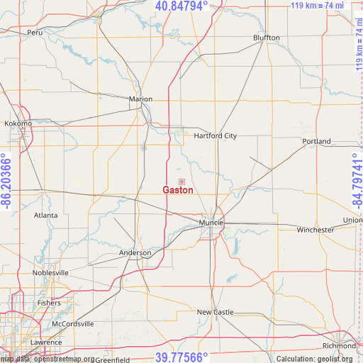
Gaston GPS coordinates[2]
40° 18' 50.148" North, 85° 30' 1.908" West
| Map corner | latitude | longitude |
|---|---|---|
| Upper-left | 40.84794°, | -86.20366° |
| Center: | 40.31393°, | -85.50053° |
| Lower-right: | 39.77566°, | -84.79741° |
| Map W x H: | 119.2×119.2 km | = 74.1×74.1mi |
| max Lat: | 71.29058° ⇑43.2% North |
| Gaston: | 40.31393° |
| min Lat: | ⇓56.8% South 19.06759° |
| min Long | Gaston | max Long |
| -171.73463° | -85.50053° | -66.98998° |
| W 54.6%⇐ | ⇒45.4% E |
Elevation
Elevation of Gaston is 272 m = 892 ft, and this is 22.8 m = 75 ft below average elevation for this country.
| Max E: |
3189 m = 10463 ft | 32.8% |
| Avg. | 294.8 m = 967 ft | |
| Gaston | 272 m = 892 ft | |
Min E: |
-60 m = -197 ft | 67.2% |
See also: United States elevation on elevation.city.
Geographical zone
Gaston is located in North temperate zone (between Tropic of Cancer and the Arctic Circle). Distance of this Northern Tropic circle is 1876.6 km =1166.1 mi to South.| Distance of | km | miles | from Gaston |
|---|---|---|---|
| North Pole | 5524.6 | 3432.8 | to North |
| Arctic Circle | 2918.7 | 1813.6 | to North |
| Tropic Cancer | 1876.6 | 1166.1 | to South |
| Equator | 4482.5 | 2785.3 | to South |


Nearby cities:
15 places around Gaston: (largest is in red/bold)
• Albany
22 km =13.7 mi,  93°
93°
• Alexandria
15.9 km =9.9 mi,  249°
249°
• Chesterfield
23.8 km =14.8 mi,  200°
200°
• Daleville
22 km =13.7 mi,  192°
192°
• Eaton
13 km =8.1 mi,  76°
76°
• Fairmount
17 km =10.6 mi,  311°
311°
• Gas City
21.5 km =13.4 mi,  333°
333°
• Hartford City
18.8 km =11.7 mi,  35°
35°
• Jonesboro
21.4 km =13.3 mi, 329°
• Matthews
8.3 km =5.2 mi,  0°
0°
• Muncie
16.5 km =10.3 mi,  144°
144°
• Selma
23.9 km =14.9 mi,  124°
124°
• Summitville
12.5 km =7.8 mi,  282°
282°
• Upland
18 km =11.2 mi, 1°
• Yorktown
15.6 km =9.7 mi,  178°
178°
Sources, notices
• [Note1] Compared only with cities in United States existing in our database
• [Src1] Map data: © OpenStreetMap contributors (CC-BY-SA)
• [Src2] Other city data from geonames.org with taken over terms of usage.
• [Src3] Geographical zone / Annual Mean Temperature by Robert A. Rohde @ Wikipedia
