Swayzee geodata
Swayzee (Indiana) is a populated place; located in United States in America/Indiana/Indianapolis (GMT-4) time zone. With population of 952 people, there are 16623 cities with bigger population in this country. Compared to other cities in United States, 59% of cities are located further ↓South; 53.4% of cities are located further ←West and 65.6% of cities have lower elevation than Swayzee. Note1


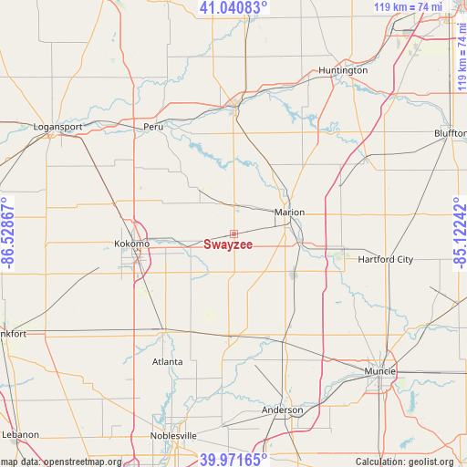
Swayzee GPS coordinates[2]
40° 30' 30.132" North, 85° 49' 31.944" West
| Map corner | latitude | longitude |
|---|---|---|
| Upper-left | 41.04083°, | -86.52867° |
| Center: | 40.50837°, | -85.82554° |
| Lower-right: | 39.97165°, | -85.12242° |
| Map W x H: | 118.9×118.9 km | = 73.9×73.9mi |
| max Lat: | 71.29058° ⇑41% North |
| Swayzee: | 40.50837° |
| min Lat: | ⇓59% South 19.06759° |
| min Long | Swayzee | max Long |
| -171.73463° | -85.82554° | -66.98998° |
| W 53.4%⇐ | ⇒46.6% E |
Elevation
Elevation of Swayzee is 265 m = 869 ft, and this is 29.8 m = 98 ft below average elevation for this country.
| Max E: |
3189 m = 10463 ft | 34.4% |
| Avg. | 294.8 m = 967 ft | |
| Swayzee | 265 m = 869 ft | |
Min E: |
-60 m = -197 ft | 65.6% |
See also: United States elevation on elevation.city.
Geographical zone
Swayzee is located in North temperate zone (between Tropic of Cancer and the Arctic Circle). Distance of this Northern Tropic circle is 1898.2 km =1179.5 mi to South.| Distance of | km | miles | from Swayzee |
|---|---|---|---|
| North Pole | 5503 | 3419.4 | to North |
| Arctic Circle | 2897.1 | 1800.2 | to North |
| Tropic Cancer | 1898.2 | 1179.5 | to South |
| Equator | 4504.1 | 2798.7 | to South |


Nearby cities:
15 places around Swayzee: (largest is in red/bold)
• Converse
8.7 km =5.4 mi,  332°
332°
• Elwood
25.8 km =16 mi,  183°
183°
• Fairmount
18.1 km =11.2 mi,  124°
124°
• Gas City
18.1 km =11.2 mi,  97°
97°
• Greentown
12.4 km =7.7 mi,  254°
254°
• Indian Heights
26.9 km =16.7 mi, 250°
• Jonesboro
17 km =10.6 mi, 100°
• Kokomo
26.2 km =16.3 mi,  264°
264°
• La Fontaine
20.4 km =12.7 mi,  25°
25°
• Marion
15.1 km =9.4 mi,  68°
68°
• Mount Vernon
17.9 km =11.1 mi,  0°
0°
• Sharpsville
26.5 km =16.5 mi,  237°
237°
• Summitville
24.3 km =15.1 mi,  140°
140°
• Sweetser
8.5 km =5.3 mi, 33°
• Windfall
19.6 km =12.2 mi,  214°
214°
Sources, notices
• [Note1] Compared only with cities in United States existing in our database
• [Src1] Map data: © OpenStreetMap contributors (CC-BY-SA)
• [Src2] Other city data from geonames.org with taken over terms of usage.
• [Src3] Geographical zone / Annual Mean Temperature by Robert A. Rohde @ Wikipedia
