Sharpsville geodata
Sharpsville (Indiana) is a populated place; located in United States in America/Indiana/Indianapolis (GMT-4) time zone. With population of 580 people, there are 19917 cities with bigger population in this country. Compared to other cities in United States, 57.6% of cities are located further ↓South; 52.7% of cities are located further ←West and 66.7% of cities have lower elevation than Sharpsville. Note1


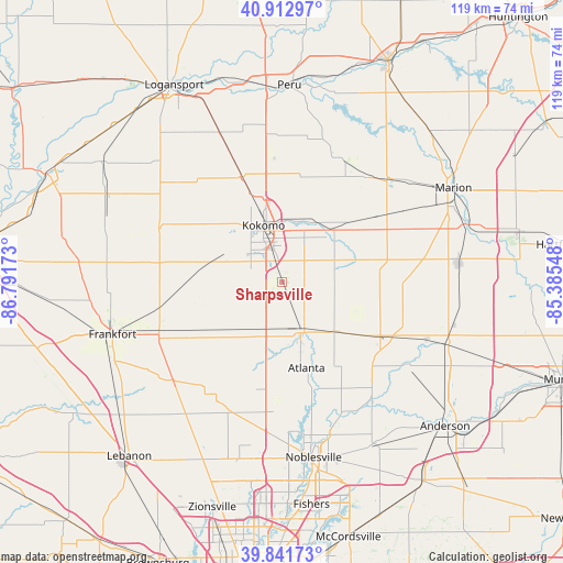
Sharpsville GPS coordinates[2]
40° 22' 46.128" North, 86° 5' 18.96" West
| Map corner | latitude | longitude |
|---|---|---|
| Upper-left | 40.91297°, | -86.79173° |
| Center: | 40.37948°, | -86.0886° |
| Lower-right: | 39.84173°, | -85.38548° |
| Map W x H: | 119.1×119.1 km | = 74×74mi |
| max Lat: | 71.29058° ⇑42.4% North |
| Sharpsville: | 40.37948° |
| min Lat: | ⇓57.6% South 19.06759° |
| min Long | Sharpsville | max Long |
| -171.73463° | -86.0886° | -66.98998° |
| W 52.7%⇐ | ⇒47.3% E |
Elevation
Elevation of Sharpsville is 270 m = 886 ft, and this is 24.8 m = 81 ft below average elevation for this country.
| Max E: |
3189 m = 10463 ft | 33.3% |
| Avg. | 294.8 m = 967 ft | |
| Sharpsville | 270 m = 886 ft | |
Min E: |
-60 m = -197 ft | 66.7% |
See also: United States elevation on elevation.city.
Geographical zone
Sharpsville is located in North temperate zone (between Tropic of Cancer and the Arctic Circle). Distance of this Northern Tropic circle is 1883.9 km =1170.6 mi to South.| Distance of | km | miles | from Sharpsville |
|---|---|---|---|
| North Pole | 5517.3 | 3428.3 | to North |
| Arctic Circle | 2911.4 | 1809.1 | to North |
| Tropic Cancer | 1883.9 | 1170.6 | to South |
| Equator | 4489.8 | 2789.8 | to South |


Nearby cities:
15 places around Sharpsville: (largest is in red/bold)
• Arcadia
23.3 km =14.5 mi,  165°
165°
• Atlanta
19 km =11.8 mi,  163°
163°
• Burlington
28.2 km =17.5 mi,  293°
293°
• Cicero
29.1 km =18.1 mi, 167°
• Converse
28.6 km =17.8 mi,  39°
39°
• Elwood
23.8 km =14.8 mi,  118°
118°
• Galveston
23.8 km =14.8 mi,  338°
338°
• Greentown
15.1 km =9.4 mi, 43°
• Indian Heights
6.2 km =3.9 mi,  329°
329°
• Kokomo
12.5 km =7.8 mi, 342°
• Russiaville
16 km =9.9 mi, 285°
• Sheridan
29.4 km =18.3 mi,  202°
202°
• Swayzee
26.5 km =16.5 mi,  57°
57°
• Tipton
11.5 km =7.1 mi, 159°
• Windfall
11.3 km =7 mi,  99°
99°
Sources, notices
• [Note1] Compared only with cities in United States existing in our database
• [Src1] Map data: © OpenStreetMap contributors (CC-BY-SA)
• [Src2] Other city data from geonames.org with taken over terms of usage.
• [Src3] Geographical zone / Annual Mean Temperature by Robert A. Rohde @ Wikipedia
