Wabash geodata
Wabash (Indiana) is a seat of a second-order administrative division; located in United States in America/Indiana/Indianapolis (GMT-4) time zone. With population of 10,381 people, there are 4356 cities with bigger population in this country. Compared to other cities in United States, 63.1% of cities are located further ↓South; 53.4% of cities are located further ←West and 54.4% of cities have lower elevation than Wabash. Note1


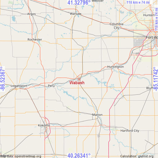
Wabash GPS coordinates[2]
40° 47' 52.152" North, 85° 49' 13.944" West
| Map corner | latitude | longitude |
|---|---|---|
| Upper-left | 41.32796°, | -86.52367° |
| Center: | 40.79782°, | -85.82054° |
| Lower-right: | 40.26341°, | -85.11742° |
| Map W x H: | 118.4×118.4 km | = 73.6×73.6mi |
| max Lat: | 71.29058° ⇑36.9% North |
| Wabash: | 40.79782° |
| min Lat: | ⇓63.1% South 19.06759° |
| min Long | Wabash | max Long |
| -171.73463° | -85.82054° | -66.98998° |
| W 53.4%⇐ | ⇒46.6% E |
Elevation
Elevation of Wabash is 216 m = 709 ft, and this is 78.8 m = 259 ft below average elevation for this country.
| Max E: |
3189 m = 10463 ft | 45.6% |
| Avg. | 294.8 m = 967 ft | |
| Wabash | 216 m = 709 ft | |
Min E: |
-60 m = -197 ft | 54.4% |
See also: United States elevation on elevation.city.
Geographical zone
Wabash is located in North temperate zone (between Tropic of Cancer and the Arctic Circle). Distance of this Northern Tropic circle is 1930.4 km =1199.5 mi to South.| Distance of | km | miles | from Wabash |
|---|---|---|---|
| North Pole | 5470.8 | 3399.4 | to North |
| Arctic Circle | 2864.9 | 1780.2 | to North |
| Tropic Cancer | 1930.4 | 1199.5 | to South |
| Equator | 4536.3 | 2818.7 | to South |


Nearby cities:
15 places around Wabash: (largest is in red/bold)
• Akron
31.9 km =19.8 mi,  326°
326°
• Andrews
19.8 km =12.3 mi,  68°
68°
• Bunker Hill
28.3 km =17.6 mi,  237°
237°
• Converse
24.9 km =15.5 mi,  190°
190°
• Grissom Air Force Base
31.7 km =19.7 mi, 240°
• Huntington
28.8 km =17.9 mi, 70°
• La Fontaine
16.1 km =10 mi,  148°
148°
• Laketon
19.7 km =12.2 mi,  356°
356°
• Marion
29.9 km =18.6 mi, 152°
• Mexico
25 km =15.5 mi,  276°
276°
• Mount Vernon
14.3 km =8.9 mi,  181°
181°
• North Manchester
23 km =14.3 mi,  10°
10°
• Peru
21.5 km =13.4 mi,  256°
256°
• Silver Lake
31.1 km =19.3 mi,  348°
348°
• Sweetser
25.5 km =15.8 mi,  170°
170°
Sources, notices
• [Note1] Compared only with cities in United States existing in our database
• [Src1] Map data: © OpenStreetMap contributors (CC-BY-SA)
• [Src2] Other city data from geonames.org with taken over terms of usage.
• [Src3] Geographical zone / Annual Mean Temperature by Robert A. Rohde @ Wikipedia
