Laketon geodata
Laketon (Indiana) is a populated place; located in United States in America/Indiana/Indianapolis (GMT-4) time zone. With population of 623 people, there are 19434 cities with bigger population in this country. Compared to other cities in United States, 65.6% of cities are located further ↓South; 53.3% of cities are located further ←West and 58.6% of cities have lower elevation than Laketon. Note1


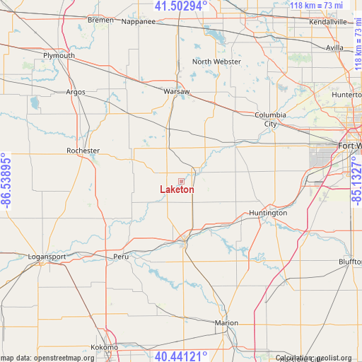
Laketon GPS coordinates[2]
40° 58' 27.156" North, 85° 50' 8.952" West
| Map corner | latitude | longitude |
|---|---|---|
| Upper-left | 41.50294°, | -86.53895° |
| Center: | 40.97421°, | -85.83582° |
| Lower-right: | 40.44121°, | -85.1327° |
| Map W x H: | 118.1×118.1 km | = 73.4×73.4mi |
| max Lat: | 71.29058° ⇑34.4% North |
| Laketon: | 40.97421° |
| min Lat: | ⇓65.6% South 19.06759° |
| min Long | Laketon | max Long |
| -171.73463° | -85.83582° | -66.98998° |
| W 53.3%⇐ | ⇒46.7% E |
Elevation
Elevation of Laketon is 233 m = 764 ft, and this is 61.8 m = 203 ft below average elevation for this country.
| Max E: |
3189 m = 10463 ft | 41.4% |
| Avg. | 294.8 m = 967 ft | |
| Laketon | 233 m = 764 ft | |
Min E: |
-60 m = -197 ft | 58.6% |
See also: United States elevation on elevation.city.
Geographical zone
Laketon is located in North temperate zone (between Tropic of Cancer and the Arctic Circle). Distance of this Northern Tropic circle is 1950 km =1211.7 mi to South.| Distance of | km | miles | from Laketon |
|---|---|---|---|
| North Pole | 5451.2 | 3387.2 | to North |
| Arctic Circle | 2845.3 | 1768 | to North |
| Tropic Cancer | 1950 | 1211.7 | to South |
| Equator | 4555.9 | 2830.9 | to South |


Nearby cities:
15 places around Laketon: (largest is in red/bold)
• Akron
17.6 km =10.9 mi,  293°
293°
• Andrews
23.3 km =14.5 mi,  122°
122°
• Huntington
30.2 km =18.8 mi,  109°
109°
• Mentone
27.7 km =17.2 mi,  323°
323°
• Mexico
29 km =18 mi,  234°
234°
• Mount Vernon
33.9 km =21.1 mi,  178°
178°
• North Manchester
6.4 km =4 mi,  62°
62°
• Peru
31.4 km =19.5 mi,  218°
218°
• Pierceton
27.4 km =17 mi,  23°
23°
• Rochester
33.4 km =20.8 mi, 287°
• Silver Lake
11.9 km =7.4 mi,  336°
336°
• South Whitley
21.3 km =13.2 mi,  54°
54°
• Wabash
19.7 km =12.2 mi, 176°
• Warsaw
29.4 km =18.3 mi,  357°
357°
• Winona Lake
28.2 km =17.5 mi,  2°
2°
Sources, notices
• [Note1] Compared only with cities in United States existing in our database
• [Src1] Map data: © OpenStreetMap contributors (CC-BY-SA)
• [Src2] Other city data from geonames.org with taken over terms of usage.
• [Src3] Geographical zone / Annual Mean Temperature by Robert A. Rohde @ Wikipedia
