Attleboro geodata
Attleboro (Massachusetts) is a populated place; located in United States in America/New_York (GMT-4) time zone. With population of 44,284 people, there are 1075 cities with bigger population in this country. Compared to other cities in United States, 75.2% of cities are located further ↓South; 97.1% of cities are located further ←West and 91.5% of cities have higher elevation than Attleboro. Note1
Administrative division(s):
- Level 1: Massachusetts
- Level 2: Bristol County
- Level 3: City of Attleboro


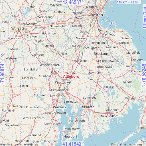
Attleboro GPS coordinates[2]
41° 56' 40.344" North, 71° 17' 8.196" West
| Map corner | latitude | longitude |
|---|---|---|
| Upper-left | 42.46537°, | -71.98874° |
| Center: | 41.94454°, | -71.28561° |
| Lower-right: | 41.41942°, | -70.58249° |
| Map W x H: | 116.3×116.3 km | = 72.3×72.3mi |
| max Lat: | 71.29058° ⇑24.8% North |
| Attleboro: | 41.94454° |
| min Lat: | ⇓75.2% South 19.06759° |
| min Long | Attleboro | max Long |
| -171.73463° | -71.28561° | -66.98998° |
| W 97.1%⇐ | ⇒2.9% E |
Elevation
Elevation of Attleboro is 13 m = 43 ft, and this is 281.8 m = 925 ft below average elevation for this country.
| Max E: |
3189 m = 10463 ft | 91.5% |
| Avg. | 294.8 m = 967 ft | |
| Attleboro | 13 m = 43 ft | |
Min E: |
-60 m = -197 ft | 8.5% |
See also: Attleboro elevation on elevation.city.
Geographical zone
Attleboro is located in North temperate zone (between Tropic of Cancer and the Arctic Circle). Distance of this Northern Tropic circle is 2057.9 km =1278.7 mi to South.| Distance of | km | miles | from Attleboro |
|---|---|---|---|
| North Pole | 5343.3 | 3320.2 | to North |
| Arctic Circle | 2737.4 | 1700.9 | to North |
| Tropic Cancer | 2057.9 | 1278.7 | to South |
| Equator | 4663.8 | 2898 | to South |


Nearby cities:
15 places around Attleboro: (largest is in red/bold)
• Central Falls
10.7 km =6.6 mi,  235°
235°
• Cumberland
12.4 km =7.7 mi,  281°
281°
• Foxborough
13.8 km =8.6 mi,  13°
13°
• Lincoln
12.6 km =7.8 mi,  258°
258°
• Mansfield
11.3 km =7 mi,  29°
29°
• Mansfield Center
10.3 km =6.4 mi, 32°
• North Attleborough Center
4.5 km =2.8 mi,  313°
313°
• North Seekonk
7.2 km =4.5 mi,  210°
210°
• Norton
8.5 km =5.3 mi,  73°
73°
• Norton Center
8.9 km =5.5 mi, 69°
• Pawtucket
10.9 km =6.8 mi,  227°
227°
• Plainville
7.7 km =4.8 mi,  329°
329°
• Rehoboth
12 km =7.5 mi,  165°
165°
• Valley Falls
9.6 km =6 mi, 244°
• Wrentham
14 km =8.7 mi,  345°
345°
Sources, notices
• [Note1] Compared only with cities in United States existing in our database
• [Src1] Map data: © OpenStreetMap contributors (CC-BY-SA)
• [Src2] Other city data from geonames.org with taken over terms of usage.
• [Src3] Geographical zone / Annual Mean Temperature by Robert A. Rohde @ Wikipedia
