Wrentham geodata
Wrentham (Massachusetts) is a populated place; located in United States in America/New_York (GMT-4) time zone. With population of 11,251 people, there are 4100 cities with bigger population in this country. Compared to other cities in United States, 76.2% of cities are located further ↓South; 97% of cities are located further ←West and 74% of cities have higher elevation than Wrentham. Note1
Administrative division(s):
- Level 1: Massachusetts
- Level 2: Norfolk County
- Level 3: Town of Wrentham


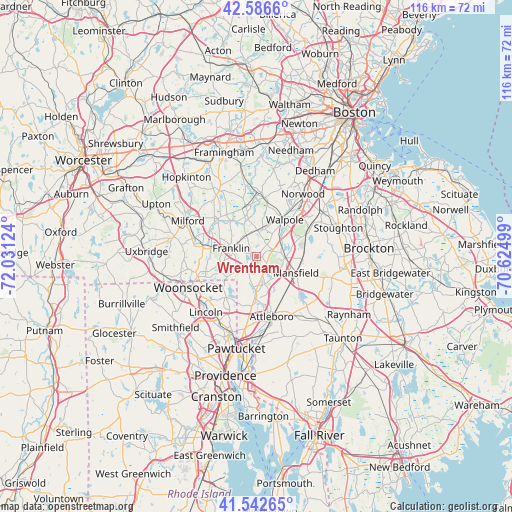
Wrentham GPS coordinates[2]
42° 4' 0.372" North, 71° 19' 41.196" West
| Map corner | latitude | longitude |
|---|---|---|
| Upper-left | 42.5866°, | -72.03124° |
| Center: | 42.06677°, | -71.32811° |
| Lower-right: | 41.54265°, | -70.62499° |
| Map W x H: | 116.1×116.1 km | = 72.1×72.1mi |
| max Lat: | 71.29058° ⇑23.8% North |
| Wrentham: | 42.06677° |
| min Lat: | ⇓76.2% South 19.06759° |
| min Long | Wrentham | max Long |
| -171.73463° | -71.32811° | -66.98998° |
| W 97%⇐ | ⇒3% E |
Elevation
Elevation of Wrentham is 77 m = 253 ft, and this is 217.8 m = 715 ft below average elevation for this country.
| Max E: |
3189 m = 10463 ft | 74% |
| Avg. | 294.8 m = 967 ft | |
| Wrentham | 77 m = 253 ft | |
Min E: |
-60 m = -197 ft | 26% |
See also: United States elevation on elevation.city.
Geographical zone
Wrentham is located in North temperate zone (between Tropic of Cancer and the Arctic Circle). Distance of this Northern Tropic circle is 2071.5 km =1287.2 mi to South.| Distance of | km | miles | from Wrentham |
|---|---|---|---|
| North Pole | 5329.7 | 3311.7 | to North |
| Arctic Circle | 2723.8 | 1692.5 | to North |
| Tropic Cancer | 2071.5 | 1287.2 | to South |
| Equator | 4677.4 | 2906.4 | to South |


Nearby cities:
15 places around Wrentham: (largest is in red/bold)
• Attleboro
14 km =8.7 mi,  165°
165°
• Bellingham
12.3 km =7.6 mi,  280°
280°
• Foxborough
6.6 km =4.1 mi,  91°
91°
• Franklin
6 km =3.7 mi,  288°
288°
• Mansfield
9.7 km =6 mi,  112°
112°
• Mansfield Center
10.3 km =6.4 mi,  118°
118°
• Medfield
13.6 km =8.5 mi,  7°
7°
• Medway
10.1 km =6.3 mi,  325°
325°
• Millis
11.5 km =7.1 mi,  347°
347°
• Millis-Clicquot
11.1 km =6.9 mi, 348°
• Norfolk
5.9 km =3.7 mi,  2°
2°
• North Attleborough Center
10.5 km =6.5 mi,  178°
178°
• Plainville
7 km =4.3 mi, 183°
• Sharon
13.9 km =8.6 mi,  62°
62°
• Walpole
10.6 km =6.6 mi,  37°
37°
Sources, notices
• [Note1] Compared only with cities in United States existing in our database
• [Src1] Map data: © OpenStreetMap contributors (CC-BY-SA)
• [Src2] Other city data from geonames.org with taken over terms of usage.
• [Src3] Geographical zone / Annual Mean Temperature by Robert A. Rohde @ Wikipedia
