Billerica geodata
Billerica (Massachusetts) is a populated place; located in United States in America/New_York (GMT-4) time zone. With population of 39,904 people, there are 1211 cities with bigger population in this country. Compared to other cities in United States, 80.2% of cities are located further ↓South; 97.1% of cities are located further ←West and 73.7% of cities have higher elevation than Billerica. Note1
Administrative division(s):
- Level 1: Massachusetts
- Level 2: Middlesex County
- Level 3: Town of Billerica


Billerica GPS coordinates[2]
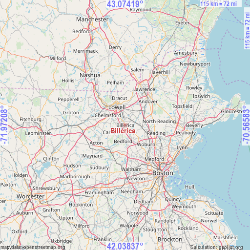
42° 33' 30.348" North, 71° 16' 8.22" West
| Map corner | latitude | longitude |
|---|---|---|
| Upper-left | 43.07419°, | -71.97208° |
| Center: | 42.55843°, | -71.26895° |
| Lower-right: | 42.03837°, | -70.56583° |
| Map W x H: | 115.2×115.2 km | = 71.6×71.6mi |
| max Lat: | 71.29058° ⇑19.8% North |
| Billerica: | 42.55843° |
| min Lat: | ⇓80.2% South 19.06759° |
| min Long | Billerica | max Long |
| -171.73463° | -71.26895° | -66.98998° |
| W 97.1%⇐ | ⇒2.9% E |
Elevation
Elevation of Billerica is 79 m = 259 ft, and this is 215.8 m = 708 ft below average elevation for this country.
| Max E: |
3189 m = 10463 ft | 73.7% |
| Avg. | 294.8 m = 967 ft | |
| Billerica | 79 m = 259 ft | |
Min E: |
-60 m = -197 ft | 26.3% |
See also: United States elevation on elevation.city.
Geographical zone
Billerica is located in North temperate zone (between Tropic of Cancer and the Arctic Circle). Distance of this Northern Tropic circle is 2126.1 km =1321.1 mi to South.| Distance of | km | miles | from Billerica |
|---|---|---|---|
| North Pole | 5275 | 3277.7 | to North |
| Arctic Circle | 2669.1 | 1658.5 | to North |
| Tropic Cancer | 2126.1 | 1321.1 | to South |
| Equator | 4732.1 | 2940.4 | to South |


Nearby cities:
15 places around Billerica: (largest is in red/bold)
• Bedford
7.6 km =4.7 mi,  184°
184°
• Burlington
8.5 km =5.3 mi,  134°
134°
• Carlisle
7.4 km =4.6 mi,  243°
243°
• Chelmsford
9.3 km =5.8 mi,  299°
299°
• Concord
12.7 km =7.9 mi,  211°
211°
• Dracut
12.7 km =7.9 mi,  347°
347°
• Lexington
12.9 km =8 mi,  163°
163°
• Lincoln
15 km =9.3 mi,  191°
191°
• Lowell
9.2 km =5.7 mi,  335°
335°
• Pinehurst
4.7 km =2.9 mi, 134°
• Reading
14.7 km =9.1 mi,  104°
104°
• Tewksbury
6.5 km =4 mi,  26°
26°
• Westford
14 km =8.7 mi,  279°
279°
• Wilmington
7.9 km =4.9 mi, 99°
• Woburn
13 km =8.1 mi, 132°
Sources, notices
• [Note1] Compared only with cities in United States existing in our database
• [Src1] Map data: © OpenStreetMap contributors (CC-BY-SA)
• [Src2] Other city data from geonames.org with taken over terms of usage.
• [Src3] Geographical zone / Annual Mean Temperature by Robert A. Rohde @ Wikipedia
