Lowell geodata
Lowell (Massachusetts) is a populated place; located in United States in America/New_York (GMT-4) time zone. With population of 110,699 people, there are 297 cities with bigger population in this country. Compared to other cities in United States, 80.8% of cities are located further ↓South; 97% of cities are located further ←West and 81.8% of cities have higher elevation than Lowell. Note1
Administrative division(s):
- Level 1: Massachusetts
- Level 2: Middlesex County
- Level 3: City of Lowell


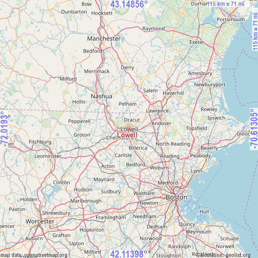
Lowell GPS coordinates[2]
42° 38' 0.312" North, 71° 18' 58.212" West
| Map corner | latitude | longitude |
|---|---|---|
| Upper-left | 43.14856°, | -72.0193° |
| Center: | 42.63342°, | -71.31617° |
| Lower-right: | 42.11398°, | -70.61305° |
| Map W x H: | 115×115 km | = 71.5×71.5mi |
| max Lat: | 71.29058° ⇑19.2% North |
| Lowell: | 42.63342° |
| min Lat: | ⇓80.8% South 19.06759° |
| min Long | Lowell | max Long |
| -171.73463° | -71.31617° | -66.98998° |
| W 97%⇐ | ⇒3% E |
Elevation
Elevation of Lowell is 39 m = 128 ft, and this is 255.8 m = 839 ft below average elevation for this country.
| Max E: |
3189 m = 10463 ft | 81.8% |
| Avg. | 294.8 m = 967 ft | |
| Lowell | 39 m = 128 ft | |
Min E: |
-60 m = -197 ft | 18.2% |
See also: Lowell elevation on elevation.city.
Geographical zone
Lowell is located in North temperate zone (between Tropic of Cancer and the Arctic Circle). Distance of this Northern Tropic circle is 2134.5 km =1326.3 mi to South.| Distance of | km | miles | from Lowell |
|---|---|---|---|
| North Pole | 5266.7 | 3272.6 | to North |
| Arctic Circle | 2660.8 | 1653.3 | to North |
| Tropic Cancer | 2134.5 | 1326.3 | to South |
| Equator | 4740.4 | 2945.5 | to South |


Nearby cities:
15 places around Lowell: (largest is in red/bold)
• Andover
14.9 km =9.3 mi,  79°
79°
• Bedford
16.2 km =10.1 mi,  168°
168°
• Billerica
9.2 km =5.7 mi,  155°
155°
• Carlisle
11.9 km =7.4 mi,  193°
193°
• Chelmsford
5.6 km =3.5 mi,  228°
228°
• Dracut
4.3 km =2.7 mi,  15°
15°
• Dunstable
14.4 km =8.9 mi,  288°
288°
• Lawrence
15 km =9.3 mi,  56°
56°
• Methuen
14.5 km =9 mi,  44°
44°
• Pelham
11.3 km =7 mi,  356°
356°
• Pinehurst
13.6 km =8.5 mi,  148°
148°
• Tewksbury
7.2 km =4.5 mi,  110°
110°
• Tyngsboro
10.1 km =6.3 mi,  298°
298°
• Westford
11.6 km =7.2 mi,  238°
238°
• Wilmington
15.1 km =9.4 mi,  129°
129°
Sources, notices
• [Note1] Compared only with cities in United States existing in our database
• [Src1] Map data: © OpenStreetMap contributors (CC-BY-SA)
• [Src2] Other city data from geonames.org with taken over terms of usage.
• [Src3] Geographical zone / Annual Mean Temperature by Robert A. Rohde @ Wikipedia
