Brockton geodata
Brockton (Massachusetts) is a populated place; located in United States in America/New_York (GMT-4) time zone. With population of 95,314 people, there are 373 cities with bigger population in this country. Compared to other cities in United States, 76.4% of cities are located further ↓South; 97.6% of cities are located further ←West and 82.3% of cities have higher elevation than Brockton. Note1
Administrative division(s):
- Level 1: Massachusetts
- Level 2: Plymouth County
- Level 3: City of Brockton


Brockton GPS coordinates[2]
42° 5' 0.348" North, 71° 1' 6.168" West
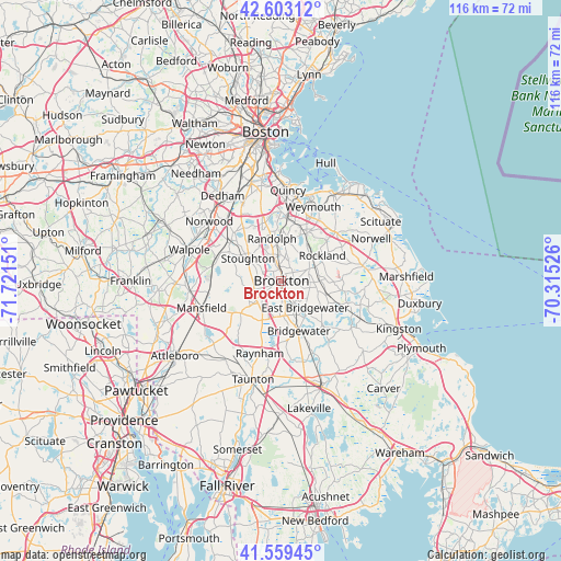
| Map corner | latitude | longitude |
|---|---|---|
| Upper-left | 42.60312°, | -71.72151° |
| Center: | 42.08343°, | -71.01838° |
| Lower-right: | 41.55945°, | -70.31526° |
| Map W x H: | 116×116 km | = 72.1×72.1mi |
| max Lat: | 71.29058° ⇑23.6% North |
| Brockton: | 42.08343° |
| min Lat: | ⇓76.4% South 19.06759° |
| min Long | Brockton | max Long |
| -171.73463° | -71.01838° | -66.98998° |
| W 97.6%⇐ | ⇒2.4% E |
Elevation
Elevation of Brockton is 37 m = 121 ft, and this is 257.8 m = 846 ft below average elevation for this country.
| Max E: |
3189 m = 10463 ft | 82.3% |
| Avg. | 294.8 m = 967 ft | |
| Brockton | 37 m = 121 ft | |
Min E: |
-60 m = -197 ft | 17.7% |
See also: Brockton elevation on elevation.city.
Geographical zone
Brockton is located in North temperate zone (between Tropic of Cancer and the Arctic Circle). Distance of this Northern Tropic circle is 2073.3 km =1288.3 mi to South.| Distance of | km | miles | from Brockton |
|---|---|---|---|
| North Pole | 5327.8 | 3310.5 | to North |
| Arctic Circle | 2721.9 | 1691.3 | to North |
| Tropic Cancer | 2073.3 | 1288.3 | to South |
| Equator | 4679.2 | 2907.5 | to South |


Nearby cities:
15 places around Brockton: (largest is in red/bold)
• Abington
6.5 km =4 mi,  68°
68°
• Avon
5.6 km =3.5 mi,  340°
340°
• Braintree
13.5 km =8.4 mi,  5°
5°
• Bridgewater
10.9 km =6.8 mi,  160°
160°
• Canton
13.3 km =8.3 mi,  308°
308°
• East Bridgewater
7.4 km =4.6 mi,  138°
138°
• Easton
11.2 km =7 mi,  234°
234°
• Hanson
11.5 km =7.1 mi,  94°
94°
• Holbrook
8 km =5 mi, 5°
• Randolph
9 km =5.6 mi,  347°
347°
• Rockland
9.9 km =6.2 mi,  58°
58°
• Sharon
14 km =8.7 mi,  288°
288°
• Stoughton
8.3 km =5.2 mi,  303°
303°
• West Bridgewater
7.2 km =4.5 mi,  173°
173°
• Whitman
6.8 km =4.2 mi, 92°
Sources, notices
• [Note1] Compared only with cities in United States existing in our database
• [Src1] Map data: © OpenStreetMap contributors (CC-BY-SA)
• [Src2] Other city data from geonames.org with taken over terms of usage.
• [Src3] Geographical zone / Annual Mean Temperature by Robert A. Rohde @ Wikipedia
