Bridgewater geodata
Bridgewater (Massachusetts) is a populated place; located in United States in America/New_York (GMT-4) time zone. With population of 7,841 people, there are 5364 cities with bigger population in this country. Compared to other cities in United States, 75.6% of cities are located further ↓South; 97.7% of cities are located further ←West and 83.2% of cities have higher elevation than Bridgewater. Note1
Administrative division(s):
- Level 1: Massachusetts
- Level 2: Plymouth County
- Level 3: Town of Bridgewater


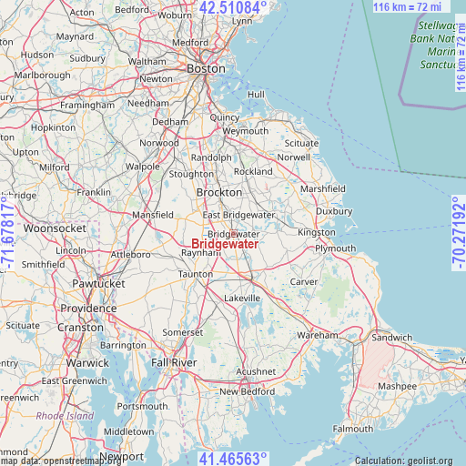
Bridgewater GPS coordinates[2]
41° 59' 25.368" North, 70° 58' 30.144" West
| Map corner | latitude | longitude |
|---|---|---|
| Upper-left | 42.51084°, | -71.67817° |
| Center: | 41.99038°, | -70.97504° |
| Lower-right: | 41.46563°, | -70.27192° |
| Map W x H: | 116.2×116.2 km | = 72.2×72.2mi |
| max Lat: | 71.29058° ⇑24.4% North |
| Bridgewater: | 41.99038° |
| min Lat: | ⇓75.6% South 19.06759° |
| min Long | Bridgewater | max Long |
| -171.73463° | -70.97504° | -66.98998° |
| W 97.7%⇐ | ⇒2.3% E |
Elevation
Elevation of Bridgewater is 34 m = 112 ft, and this is 260.8 m = 856 ft below average elevation for this country.
| Max E: |
3189 m = 10463 ft | 83.2% |
| Avg. | 294.8 m = 967 ft | |
| Bridgewater | 34 m = 112 ft | |
Min E: |
-60 m = -197 ft | 16.8% |
See also: United States elevation on elevation.city.
Geographical zone
Bridgewater is located in North temperate zone (between Tropic of Cancer and the Arctic Circle). Distance of this Northern Tropic circle is 2063 km =1281.9 mi to South.| Distance of | km | miles | from Bridgewater |
|---|---|---|---|
| North Pole | 5338.2 | 3317 | to North |
| Arctic Circle | 2732.3 | 1697.8 | to North |
| Tropic Cancer | 2063 | 1281.9 | to South |
| Equator | 4668.9 | 2901.1 | to South |


Nearby cities:
15 places around Bridgewater: (largest is in red/bold)
• Abington
13 km =8.1 mi,  10°
10°
• Brockton
10.9 km =6.8 mi,  340°
340°
• East Bridgewater
5 km =3.1 mi,  15°
15°
• Easton
13.2 km =8.2 mi,  286°
286°
• Halifax
9.3 km =5.8 mi,  89°
89°
• Hanson
12.3 km =7.6 mi,  39°
39°
• Middleborough
12 km =7.5 mi,  153°
153°
• Middleborough Center
11.4 km =7.1 mi,  159°
159°
• North Lakeville
15 km =9.3 mi,  169°
169°
• Plympton
13.9 km =8.6 mi,  107°
107°
• Raynham
9.3 km =5.8 mi,  240°
240°
• Raynham Center
9.8 km =6.1 mi,  220°
220°
• Taunton
13.8 km =8.6 mi, 223°
• West Bridgewater
4.2 km =2.6 mi,  319°
319°
• Whitman
10.6 km =6.6 mi, 17°
Sources, notices
• [Note1] Compared only with cities in United States existing in our database
• [Src1] Map data: © OpenStreetMap contributors (CC-BY-SA)
• [Src2] Other city data from geonames.org with taken over terms of usage.
• [Src3] Geographical zone / Annual Mean Temperature by Robert A. Rohde @ Wikipedia
