Buckland geodata
Buckland (Massachusetts) is a populated place; located in United States in America/New_York (GMT-4) time zone. With population of 2,026 people, there are 11876 cities with bigger population in this country. Compared to other cities in United States, 80.5% of cities are located further ↓South; 94.3% of cities are located further ←West and 54.2% of cities have lower elevation than Buckland. Note1
Administrative division(s):
- Level 1: Massachusetts
- Level 2: Franklin County
- Level 3: Town of Buckland


Buckland GPS coordinates[2]
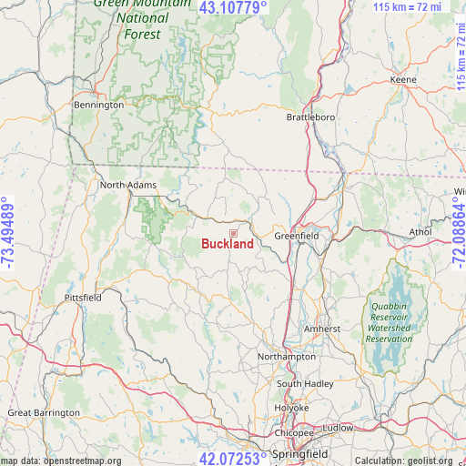
42° 35' 32.316" North, 72° 47' 30.336" West
| Map corner | latitude | longitude |
|---|---|---|
| Upper-left | 43.10779°, | -73.49489° |
| Center: | 42.59231°, | -72.79176° |
| Lower-right: | 42.07253°, | -72.08864° |
| Map W x H: | 115.1×115.1 km | = 71.5×71.5mi |
| max Lat: | 71.29058° ⇑19.5% North |
| Buckland: | 42.59231° |
| min Lat: | ⇓80.5% South 19.06759° |
| min Long | Buckland | max Long |
| -171.73463° | -72.79176° | -66.98998° |
| W 94.3%⇐ | ⇒5.7% E |
Elevation
Elevation of Buckland is 215 m = 705 ft, and this is 79.8 m = 262 ft below average elevation for this country.
| Max E: |
3189 m = 10463 ft | 45.8% |
| Avg. | 294.8 m = 967 ft | |
| Buckland | 215 m = 705 ft | |
Min E: |
-60 m = -197 ft | 54.2% |
See also: United States elevation on elevation.city.
Geographical zone
Buckland is located in North temperate zone (between Tropic of Cancer and the Arctic Circle). Distance of this Northern Tropic circle is 2129.9 km =1323.5 mi to South.| Distance of | km | miles | from Buckland |
|---|---|---|---|
| North Pole | 5271.2 | 3275.4 | to North |
| Arctic Circle | 2665.4 | 1656.2 | to North |
| Tropic Cancer | 2129.9 | 1323.5 | to South |
| Equator | 4735.8 | 2942.7 | to South |


Nearby cities:
15 places around Buckland: (largest is in red/bold)
• Ashfield
7.3 km =4.5 mi,  177°
177°
• Charlemont
7.5 km =4.7 mi,  301°
301°
• Colrain
11.9 km =7.4 mi,  40°
40°
• Conway
11.9 km =7.4 mi,  140°
140°
• Cummington
16.8 km =10.4 mi,  209°
209°
• Deerfield
16.1 km =10 mi,  109°
109°
• Goshen
16.9 km =10.5 mi, 182°
• Greenfield
15.7 km =9.8 mi,  91°
91°
• Heath
9.3 km =5.8 mi,  344°
344°
• Leyden
17.8 km =11.1 mi,  47°
47°
• Savoy
19.6 km =12.2 mi,  261°
261°
• Shelburne
8.5 km =5.3 mi, 91°
• Shelburne Falls
4.5 km =2.8 mi,  72°
72°
• South Deerfield
19.8 km =12.3 mi,  130°
130°
• Turners Falls
19.3 km =12 mi, 86°
Sources, notices
• [Note1] Compared only with cities in United States existing in our database
• [Src1] Map data: © OpenStreetMap contributors (CC-BY-SA)
• [Src2] Other city data from geonames.org with taken over terms of usage.
• [Src3] Geographical zone / Annual Mean Temperature by Robert A. Rohde @ Wikipedia
