Conway geodata
Conway (Massachusetts) is a populated place; located in United States in America/New_York (GMT-4) time zone. With population of 1,841 people, there are 12406 cities with bigger population in this country. Compared to other cities in United States, 79.9% of cities are located further ↓South; 94.4% of cities are located further ←West and 53.6% of cities have higher elevation than Conway. Note1


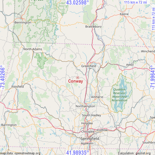
Conway GPS coordinates[2]
42° 30' 35.316" North, 72° 41' 58.308" West
| Map corner | latitude | longitude |
|---|---|---|
| Upper-left | 43.02598°, | -73.40266° |
| Center: | 42.50981°, | -72.69953° |
| Lower-right: | 41.98935°, | -71.99641° |
| Map W x H: | 115.3×115.3 km | = 71.6×71.6mi |
| max Lat: | 71.29058° ⇑20.1% North |
| Conway: | 42.50981° |
| min Lat: | ⇓79.9% South 19.06759° |
| min Long | Conway | max Long |
| -171.73463° | -72.69953° | -66.98998° |
| W 94.4%⇐ | ⇒5.6% E |
Elevation
Elevation of Conway is 185 m = 607 ft, and this is 109.8 m = 360 ft below average elevation for this country.
| Max E: |
3189 m = 10463 ft | 53.6% |
| Avg. | 294.8 m = 967 ft | |
| Conway | 185 m = 607 ft | |
Min E: |
-60 m = -197 ft | 46.4% |
See also: United States elevation on elevation.city.
Geographical zone
Conway is located in North temperate zone (between Tropic of Cancer and the Arctic Circle). Distance of this Northern Tropic circle is 2120.7 km =1317.7 mi to South.| Distance of | km | miles | from Conway |
|---|---|---|---|
| North Pole | 5280.4 | 3281.1 | to North |
| Arctic Circle | 2674.5 | 1661.9 | to North |
| Tropic Cancer | 2120.7 | 1317.7 | to South |
| Equator | 4726.6 | 2937 | to South |


Nearby cities:
15 places around Conway: (largest is in red/bold)
• Ashfield
7.5 km =4.7 mi,  284°
284°
• Buckland
11.9 km =7.4 mi,  320°
320°
• Cummington
16.8 km =10.4 mi,  251°
251°
• Deerfield
8.6 km =5.3 mi,  63°
63°
• Goshen
11.3 km =7 mi,  226°
226°
• Greenfield
11.9 km =7.4 mi,  43°
43°
• Hatfield
17.5 km =10.9 mi,  151°
151°
• Leverett
17.5 km =10.9 mi,  111°
111°
• Montague
13.8 km =8.6 mi,  77°
77°
• Shelburne
8.9 km =5.5 mi,  5°
5°
• Shelburne Falls
11 km =6.8 mi,  342°
342°
• South Deerfield
8.3 km =5.2 mi,  115°
115°
• Turners Falls
15.7 km =9.8 mi,  48°
48°
• Whately
9.4 km =5.8 mi, 145°
• Williamsburg
13.2 km =8.2 mi,  190°
190°
Sources, notices
• [Note1] Compared only with cities in United States existing in our database
• [Src1] Map data: © OpenStreetMap contributors (CC-BY-SA)
• [Src2] Other city data from geonames.org with taken over terms of usage.
• [Src3] Geographical zone / Annual Mean Temperature by Robert A. Rohde @ Wikipedia
