East Dennis geodata
East Dennis (Massachusetts) is a populated place; located in United States in America/New_York (GMT-4) time zone. With population of 2,753 people, there are 10077 cities with bigger population in this country. Compared to other cities in United States, 73.4% of cities are located further ↓South; 98.7% of cities are located further ←West and 94.8% of cities have higher elevation than East Dennis. Note1
Administrative division(s):
- Level 1: Massachusetts
- Level 2: Barnstable County
- Level 3: Town of Dennis


East Dennis GPS coordinates[2]
41° 44' 33.396" North, 70° 9' 43.056" West
| Map corner | latitude | longitude |
|---|---|---|
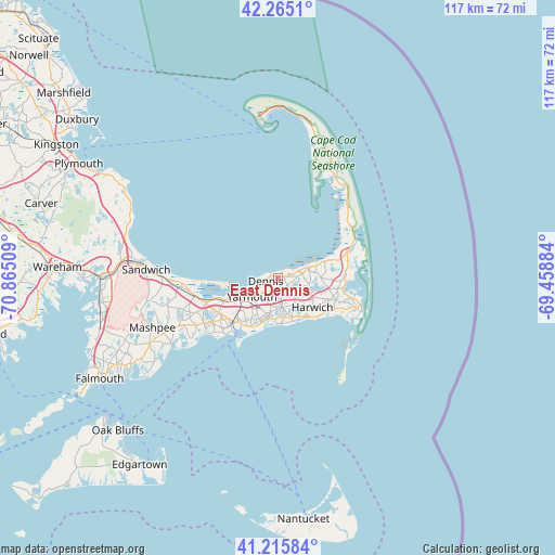
| Upper-left | 42.2651°, | -70.86509° |
| Center: | 41.74261°, | -70.16196° |
| Lower-right: | 41.21584°, | -69.45884° |
| Map W x H: | 116.7×116.7 km | = 72.5×72.5mi |
| max Lat: | 71.29058° ⇑26.6% North |
| East Dennis: | 41.74261° |
| min Lat: | ⇓73.4% South 19.06759° |
| min Long | East Dennis | max Long |
| -171.73463° | -70.16196° | -66.98998° |
| W 98.7%⇐ | ⇒1.3% E |
Elevation
Elevation of East Dennis is 9 m = 30 ft, and this is 285.8 m = 938 ft below average elevation for this country.
| Max E: |
3189 m = 10463 ft | 94.8% |
| Avg. | 294.8 m = 967 ft | |
| East Dennis | 9 m = 30 ft | |
Min E: |
-60 m = -197 ft | 5.2% |
See also: United States elevation on elevation.city.
Geographical zone
East Dennis is located in North temperate zone (between Tropic of Cancer and the Arctic Circle). Distance of this Northern Tropic circle is 2035.4 km =1264.7 mi to South.| Distance of | km | miles | from East Dennis |
|---|---|---|---|
| North Pole | 5365.7 | 3334.1 | to North |
| Arctic Circle | 2759.8 | 1714.9 | to North |
| Tropic Cancer | 2035.4 | 1264.7 | to South |
| Equator | 4641.3 | 2884 | to South |


Nearby cities:
15 places around East Dennis: (largest is in red/bold)
• Barnstable
12.4 km =7.7 mi,  247°
247°
• Brewster
6.8 km =4.2 mi,  73°
73°
• Dennis
2.8 km =1.7 mi, 253°
• Dennis Port
9.8 km =6.1 mi,  163°
163°
• East Harwich
12.1 km =7.5 mi,  112°
112°
• Harwich
9.5 km =5.9 mi,  131°
131°
• Harwich Center
9.5 km =5.9 mi, 126°
• Harwich Port
10.9 km =6.8 mi,  140°
140°
• Northwest Harwich
7.6 km =4.7 mi, 139°
• South Dennis
5.9 km =3.7 mi,  175°
175°
• South Yarmouth
8.6 km =5.3 mi,  192°
192°
• West Dennis
8.7 km =5.4 mi, 185°
• West Yarmouth
12.2 km =7.6 mi,  212°
212°
• Yarmouth
6.9 km =4.3 mi,  233°
233°
• Yarmouth Port
8.5 km =5.3 mi,  238°
238°
Sources, notices
• [Note1] Compared only with cities in United States existing in our database
• [Src1] Map data: © OpenStreetMap contributors (CC-BY-SA)
• [Src2] Other city data from geonames.org with taken over terms of usage.
• [Src3] Geographical zone / Annual Mean Temperature by Robert A. Rohde @ Wikipedia
