Barnstable geodata
Barnstable (Massachusetts) is a seat of a second-order administrative division; located in United States in America/New_York (GMT-4) time zone. With population of 47,821 people, there are 1004 cities with bigger population in this country. Compared to other cities in United States, 72.9% of cities are located further ↓South; 98.6% of cities are located further ←West and 89.1% of cities have higher elevation than Barnstable. Note1
Administrative division(s):
- Level 1: Massachusetts
- Level 2: Barnstable County
- Level 3: City of Barnstable Town


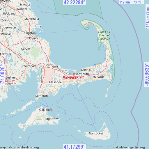
Barnstable GPS coordinates[2]
41° 42' 0.396" North, 70° 17' 58.092" West
| Map corner | latitude | longitude |
|---|---|---|
| Upper-left | 42.22294°, | -71.0026° |
| Center: | 41.70011°, | -70.29947° |
| Lower-right: | 41.17299°, | -69.59635° |
| Map W x H: | 116.7×116.7 km | = 72.5×72.5mi |
| max Lat: | 71.29058° ⇑27.1% North |
| Barnstable: | 41.70011° |
| min Lat: | ⇓72.9% South 19.06759° |
| min Long | Barnstable | max Long |
| -171.73463° | -70.29947° | -66.98998° |
| W 98.6%⇐ | ⇒1.4% E |
Elevation
Elevation of Barnstable is 18 m = 59 ft, and this is 276.8 m = 908 ft below average elevation for this country.
| Max E: |
3189 m = 10463 ft | 89.1% |
| Avg. | 294.8 m = 967 ft | |
| Barnstable | 18 m = 59 ft | |
Min E: |
-60 m = -197 ft | 10.9% |
See also: Barnstable elevation on elevation.city.
Geographical zone
Barnstable is located in North temperate zone (between Tropic of Cancer and the Arctic Circle). Distance of this Northern Tropic circle is 2030.7 km =1261.8 mi to South.| Distance of | km | miles | from Barnstable |
|---|---|---|---|
| North Pole | 5370.4 | 3337 | to North |
| Arctic Circle | 2764.6 | 1717.8 | to North |
| Tropic Cancer | 2030.7 | 1261.8 | to South |
| Equator | 4636.6 | 2881 | to South |


Nearby cities:
15 places around Barnstable: (largest is in red/bold)
• Centerville
7 km =4.3 mi,  215°
215°
• Cotuit
14.7 km =9.1 mi,  230°
230°
• Dennis
9.6 km =6 mi,  65°
65°
• East Dennis
12.4 km =7.7 mi, 67°
• East Sandwich
13.5 km =8.4 mi,  290°
290°
• Hyannis
5.4 km =3.4 mi,  165°
165°
• Marstons Mills
10.8 km =6.7 mi,  243°
243°
• Osterville
10.8 km =6.7 mi, 222°
• South Dennis
11.9 km =7.4 mi,  95°
95°
• South Yarmouth
10.2 km =6.3 mi,  111°
111°
• West Barnstable
6.3 km =3.9 mi,  275°
275°
• West Dennis
11.2 km =7 mi, 110°
• West Yarmouth
7.4 km =4.6 mi,  138°
138°
• Yarmouth
5.9 km =3.7 mi,  83°
83°
• Yarmouth Port
4.2 km =2.6 mi,  87°
87°
Sources, notices
• [Note1] Compared only with cities in United States existing in our database
• [Src1] Map data: © OpenStreetMap contributors (CC-BY-SA)
• [Src2] Other city data from geonames.org with taken over terms of usage.
• [Src3] Geographical zone / Annual Mean Temperature by Robert A. Rohde @ Wikipedia
