Housatonic geodata
Housatonic (Massachusetts) is a populated place; located in United States in America/New_York (GMT-4) time zone. With population of 1,109 people, there are 15621 cities with bigger population in this country. Compared to other cities in United States, 77.8% of cities are located further ↓South; 93.1% of cities are located further ←West and 56.1% of cities have lower elevation than Housatonic. Note1
Administrative division(s):
- Level 1: Massachusetts
- Level 2: Berkshire County
- Level 3: Town of Great Barrington


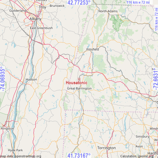
Housatonic GPS coordinates[2]
42° 15' 15.3" North, 73° 21' 58.392" West
| Map corner | latitude | longitude |
|---|---|---|
| Upper-left | 42.77253°, | -74.06935° |
| Center: | 42.25425°, | -73.36622° |
| Lower-right: | 41.73167°, | -72.6631° |
| Map W x H: | 115.7×115.7 km | = 71.9×71.9mi |
| max Lat: | 71.29058° ⇑22.2% North |
| Housatonic: | 42.25425° |
| min Lat: | ⇓77.8% South 19.06759° |
| min Long | Housatonic | max Long |
| -171.73463° | -73.36622° | -66.98998° |
| W 93.1%⇐ | ⇒6.9% E |
Elevation
Elevation of Housatonic is 223 m = 732 ft, and this is 71.8 m = 236 ft below average elevation for this country.
| Max E: |
3189 m = 10463 ft | 43.9% |
| Avg. | 294.8 m = 967 ft | |
| Housatonic | 223 m = 732 ft | |
Min E: |
-60 m = -197 ft | 56.1% |
See also: United States elevation on elevation.city.
Geographical zone
Housatonic is located in North temperate zone (between Tropic of Cancer and the Arctic Circle). Distance of this Northern Tropic circle is 2092.3 km =1300.1 mi to South.| Distance of | km | miles | from Housatonic |
|---|---|---|---|
| North Pole | 5308.8 | 3298.7 | to North |
| Arctic Circle | 2702.9 | 1679.5 | to North |
| Tropic Cancer | 2092.3 | 1300.1 | to South |
| Equator | 4698.2 | 2919.3 | to South |


Nearby cities:
15 places around Housatonic: (largest is in red/bold)
• Chatham
22.4 km =13.9 mi,  303°
303°
• Copake Lake
21.9 km =13.6 mi,  234°
234°
• Ghent
22.1 km =13.7 mi,  292°
292°
• Great Barrington
6.5 km =4 mi,  176°
176°
• Lee
11.2 km =7 mi,  60°
60°
• Lenox
13.2 km =8.2 mi,  30°
30°
• Monterey
15.2 km =9.4 mi,  123°
123°
• New Marlborough
18.5 km =11.5 mi,  142°
142°
• Otis
23.6 km =14.7 mi,  106°
106°
• Philmont
23.6 km =14.7 mi,  268°
268°
• Pittsfield
23.9 km =14.9 mi,  24°
24°
• Richmond
13.2 km =8.2 mi,  359°
359°
• Sheffield
16 km =9.9 mi, 176°
• Stockbridge
5.3 km =3.3 mi,  45°
45°
• West Stockbridge
10.2 km =6.3 mi,  0°
0°
Sources, notices
• [Note1] Compared only with cities in United States existing in our database
• [Src1] Map data: © OpenStreetMap contributors (CC-BY-SA)
• [Src2] Other city data from geonames.org with taken over terms of usage.
• [Src3] Geographical zone / Annual Mean Temperature by Robert A. Rohde @ Wikipedia
