Marlborough geodata
Marlborough (Massachusetts) is a populated place; located in United States in America/New_York (GMT-4) time zone. With population of 39,818 people, there are 1216 cities with bigger population in this country. Compared to other cities in United States, 78.5% of cities are located further ↓South; 96.5% of cities are located further ←West and 65.2% of cities have higher elevation than Marlborough. Note1
Administrative division(s):
- Level 1: Massachusetts
- Level 2: Middlesex County
- Level 3: City of Marlborough


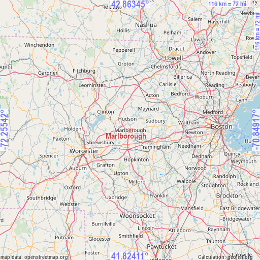
Marlborough GPS coordinates[2]
42° 20' 45.348" North, 71° 33' 8.244" West
| Map corner | latitude | longitude |
|---|---|---|
| Upper-left | 42.86345°, | -72.25542° |
| Center: | 42.34593°, | -71.55229° |
| Lower-right: | 41.82411°, | -70.84917° |
| Map W x H: | 115.6×115.6 km | = 71.8×71.8mi |
| max Lat: | 71.29058° ⇑21.5% North |
| Marlborough: | 42.34593° |
| min Lat: | ⇓78.5% South 19.06759° |
| min Long | Marlborough | max Long |
| -171.73463° | -71.55229° | -66.98998° |
| W 96.5%⇐ | ⇒3.5% E |
Elevation
Elevation of Marlborough is 127 m = 417 ft, and this is 167.8 m = 551 ft below average elevation for this country.
| Max E: |
3189 m = 10463 ft | 65.2% |
| Avg. | 294.8 m = 967 ft | |
| Marlborough | 127 m = 417 ft | |
Min E: |
-60 m = -197 ft | 34.8% |
See also: United States elevation on elevation.city.
Geographical zone
Marlborough is located in North temperate zone (between Tropic of Cancer and the Arctic Circle). Distance of this Northern Tropic circle is 2102.5 km =1306.4 mi to South.| Distance of | km | miles | from Marlborough |
|---|---|---|---|
| North Pole | 5298.6 | 3292.4 | to North |
| Arctic Circle | 2692.7 | 1673.2 | to North |
| Tropic Cancer | 2102.5 | 1306.4 | to South |
| Equator | 4708.4 | 2925.7 | to South |


Nearby cities:
15 places around Marlborough: (largest is in red/bold)
• Ashland
11.9 km =7.4 mi,  142°
142°
• Berlin
8 km =5 mi,  299°
299°
• Bolton
10.7 km =6.6 mi,  334°
334°
• Clinton
13.3 km =8.3 mi,  306°
306°
• Cordaville
8.9 km =5.5 mi,  164°
164°
• Framingham
13.4 km =8.3 mi,  123°
123°
• Framingham Center
10.9 km =6.8 mi, 119°
• Hopkinton
13.3 km =8.3 mi,  169°
169°
• Hudson
5.2 km =3.2 mi,  347°
347°
• Maynard
12.9 km =8 mi,  40°
40°
• Northborough
7.9 km =4.9 mi,  248°
248°
• Southborough
5 km =3.1 mi,  152°
152°
• Stow
10.8 km =6.7 mi,  20°
20°
• Sudbury
11.9 km =7.4 mi,  69°
69°
• Westborough
10 km =6.2 mi,  211°
211°
Sources, notices
• [Note1] Compared only with cities in United States existing in our database
• [Src1] Map data: © OpenStreetMap contributors (CC-BY-SA)
• [Src2] Other city data from geonames.org with taken over terms of usage.
• [Src3] Geographical zone / Annual Mean Temperature by Robert A. Rohde @ Wikipedia
