Framingham geodata
Framingham (Massachusetts) is a populated place; located in United States in America/New_York (GMT-4) time zone. With population of 68,318 people, there are 612 cities with bigger population in this country. Compared to other cities in United States, 78% of cities are located further ↓South; 96.8% of cities are located further ←West and 78.4% of cities have higher elevation than Framingham. Note1
Administrative division(s):
- Level 1: Massachusetts
- Level 2: Middlesex County
- Level 3: Town of Framingham


Framingham GPS coordinates[2]
42° 16' 45.336" North, 71° 24' 58.212" West
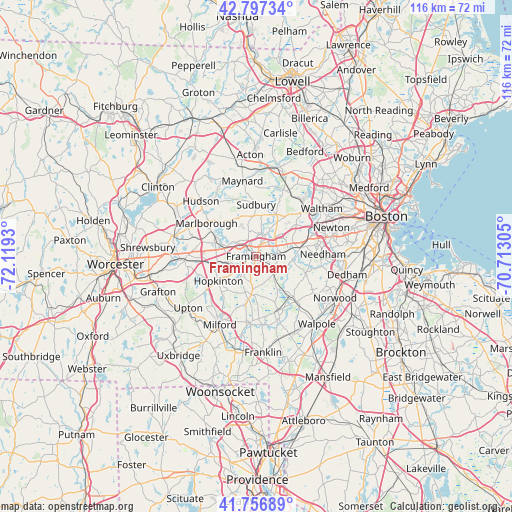
| Map corner | latitude | longitude |
|---|---|---|
| Upper-left | 42.79734°, | -72.1193° |
| Center: | 42.27926°, | -71.41617° |
| Lower-right: | 41.75689°, | -70.71305° |
| Map W x H: | 115.7×115.7 km | = 71.9×71.9mi |
| max Lat: | 71.29058° ⇑22% North |
| Framingham: | 42.27926° |
| min Lat: | ⇓78% South 19.06759° |
| min Long | Framingham | max Long |
| -171.73463° | -71.41617° | -66.98998° |
| W 96.8%⇐ | ⇒3.2% E |
Elevation
Elevation of Framingham is 54 m = 177 ft, and this is 240.8 m = 790 ft below average elevation for this country.
| Max E: |
3189 m = 10463 ft | 78.4% |
| Avg. | 294.8 m = 967 ft | |
| Framingham | 54 m = 177 ft | |
Min E: |
-60 m = -197 ft | 21.6% |
See also: Framingham elevation on elevation.city.
Geographical zone
Framingham is located in North temperate zone (between Tropic of Cancer and the Arctic Circle). Distance of this Northern Tropic circle is 2095.1 km =1301.8 mi to South.| Distance of | km | miles | from Framingham |
|---|---|---|---|
| North Pole | 5306 | 3297 | to North |
| Arctic Circle | 2700.2 | 1677.8 | to North |
| Tropic Cancer | 2095.1 | 1301.8 | to South |
| Equator | 4701 | 2921.1 | to South |


Nearby cities:
15 places around Framingham: (largest is in red/bold)
• Ashland
4.4 km =2.7 mi,  242°
242°
• Cochituate
6.3 km =3.9 mi,  42°
42°
• Cordaville
8.9 km =5.5 mi,  262°
262°
• Dover
11.6 km =7.2 mi,  108°
108°
• Framingham Center
2.6 km =1.6 mi,  319°
319°
• Holliston
8.8 km =5.5 mi,  184°
184°
• Hopkinton
10.4 km =6.5 mi, 237°
• Marlborough
13.4 km =8.3 mi,  303°
303°
• Millis
13.3 km =8.3 mi,  158°
158°
• Natick
5.5 km =3.4 mi,  85°
85°
• Sherborn
5.9 km =3.7 mi,  139°
139°
• Southborough
9.4 km =5.8 mi,  288°
288°
• Sudbury
11.6 km =7.2 mi,  0°
0°
• Wayland
10.3 km =6.4 mi,  25°
25°
• Wellesley
10.3 km =6.4 mi,  79°
79°
Sources, notices
• [Note1] Compared only with cities in United States existing in our database
• [Src1] Map data: © OpenStreetMap contributors (CC-BY-SA)
• [Src2] Other city data from geonames.org with taken over terms of usage.
• [Src3] Geographical zone / Annual Mean Temperature by Robert A. Rohde @ Wikipedia
