Chelsea geodata
Chelsea (Maine) is a populated place; located in United States in America/New_York (GMT-4) time zone. With population of 2,661 people, there are 10265 cities with bigger population in this country. Compared to other cities in United States, 89.4% of cities are located further ↓South; 99.1% of cities are located further ←West and 78.8% of cities have higher elevation than Chelsea. Note1


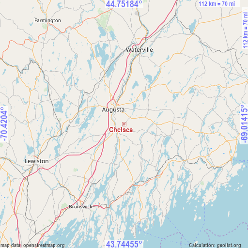
Chelsea GPS coordinates[2]
44° 15' 1.26" North, 69° 43' 2.172" West
| Map corner | latitude | longitude |
|---|---|---|
| Upper-left | 44.75184°, | -70.4204° |
| Center: | 44.25035°, | -69.71727° |
| Lower-right: | 43.74455°, | -69.01415° |
| Map W x H: | 112×112 km | = 69.6×69.6mi |
| max Lat: | 71.29058° ⇑10.6% North |
| Chelsea: | 44.25035° |
| min Lat: | ⇓89.4% South 19.06759° |
| min Long | Chelsea | max Long |
| -171.73463° | -69.71727° | -66.98998° |
| W 99.1%⇐ | ⇒0.90000000000001% E |
Elevation
Elevation of Chelsea is 52 m = 171 ft, and this is 242.8 m = 797 ft below average elevation for this country.
| Max E: |
3189 m = 10463 ft | 78.8% |
| Avg. | 294.8 m = 967 ft | |
| Chelsea | 52 m = 171 ft | |
Min E: |
-60 m = -197 ft | 21.2% |
See also: United States elevation on elevation.city.
Geographical zone
Chelsea is located in North temperate zone (between Tropic of Cancer and the Arctic Circle). Distance of this Northern Tropic circle is 2314.3 km =1438 mi to South.| Distance of | km | miles | from Chelsea |
|---|---|---|---|
| North Pole | 5086.9 | 3160.9 | to North |
| Arctic Circle | 2481 | 1541.6 | to North |
| Tropic Cancer | 2314.3 | 1438 | to South |
| Equator | 4920.2 | 3057.3 | to South |


Nearby cities:
15 places around Chelsea: (largest is in red/bold)
• Alna
18.4 km =11.4 mi,  150°
150°
• Augusta
8.3 km =5.2 mi,  323°
323°
• Farmingdale
4.4 km =2.7 mi,  261°
261°
• Gardiner
5.1 km =3.2 mi,  244°
244°
• Hallowell
7.1 km =4.4 mi,  303°
303°
• Jefferson
21.6 km =13.4 mi,  102°
102°
• Manchester
14.1 km =8.8 mi,  305°
305°
• Pittston
4.4 km =2.7 mi,  223°
223°
• Randolph
4.5 km =2.8 mi, 240°
• Richmond
19.3 km =12 mi,  199°
199°
• Sidney
18.1 km =11.2 mi,  357°
357°
• Somerville
19.3 km =12 mi,  70°
70°
• Whitefield
11.5 km =7.1 mi,  140°
140°
• Windsor
12.8 km =8 mi,  58°
58°
• Winthrop
21.6 km =13.4 mi,  286°
286°
Sources, notices
• [Note1] Compared only with cities in United States existing in our database
• [Src1] Map data: © OpenStreetMap contributors (CC-BY-SA)
• [Src2] Other city data from geonames.org with taken over terms of usage.
• [Src3] Geographical zone / Annual Mean Temperature by Robert A. Rohde @ Wikipedia
