North Windham geodata
North Windham (Maine) is a populated place; located in United States in America/New_York (GMT-4) time zone. With population of 4,904 people, there are 7267 cities with bigger population in this country. Compared to other cities in United States, 87.8% of cities are located further ↓South; 98.5% of cities are located further ←West and 71.5% of cities have higher elevation than North Windham. Note1


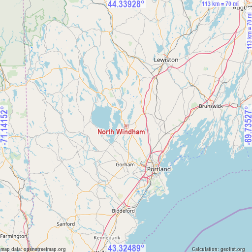
North Windham GPS coordinates[2]
43° 50' 3.264" North, 70° 26' 18.204" West
| Map corner | latitude | longitude |
|---|---|---|
| Upper-left | 44.33928°, | -71.14152° |
| Center: | 43.83424°, | -70.43839° |
| Lower-right: | 43.32489°, | -69.73527° |
| Map W x H: | 112.8×112.8 km | = 70.1×70.1mi |
| max Lat: | 71.29058° ⇑12.2% North |
| North Windham: | 43.83424° |
| min Lat: | ⇓87.8% South 19.06759° |
| min Long | North Windham | max Long |
| -171.73463° | -70.43839° | -66.98998° |
| W 98.5%⇐ | ⇒1.5% E |
Elevation
Elevation of North Windham is 92 m = 302 ft, and this is 202.8 m = 665 ft below average elevation for this country.
| Max E: |
3189 m = 10463 ft | 71.5% |
| Avg. | 294.8 m = 967 ft | |
| North Windham | 92 m = 302 ft | |
Min E: |
-60 m = -197 ft | 28.5% |
See also: United States elevation on elevation.city.
Geographical zone
North Windham is located in North temperate zone (between Tropic of Cancer and the Arctic Circle). Distance of this Northern Tropic circle is 2268 km =1409.3 mi to South.| Distance of | km | miles | from North Windham |
|---|---|---|---|
| North Pole | 5133.2 | 3189.6 | to North |
| Arctic Circle | 2527.3 | 1570.4 | to North |
| Tropic Cancer | 2268 | 1409.3 | to South |
| Equator | 4873.9 | 3028.5 | to South |


Nearby cities:
15 places around North Windham: (largest is in red/bold)
• Buxton
22.8 km =14.2 mi,  196°
196°
• Casco
20.3 km =12.6 mi,  340°
340°
• Cumberland Center
15 km =9.3 mi,  106°
106°
• Falmouth
19.6 km =12.2 mi,  126°
126°
• Falmouth Foreside
21.6 km =13.4 mi,  120°
120°
• Gorham
17.2 km =10.7 mi,  181°
181°
• Gray
10.3 km =6.4 mi,  56°
56°
• Little Falls
11.5 km =7.1 mi, 175°
• New Gloucester
19 km =11.8 mi,  41°
41°
• Raymond
7.9 km =4.9 mi, 341°
• South Portland Gardens
23.9 km =14.9 mi,  155°
155°
• South Windham
11 km =6.8 mi,  173°
173°
• Steep Falls
17.8 km =11.1 mi,  255°
255°
• Westbrook
18.3 km =11.4 mi, 162°
• Yarmouth
20.5 km =12.7 mi,  100°
100°
Sources, notices
• [Note1] Compared only with cities in United States existing in our database
• [Src1] Map data: © OpenStreetMap contributors (CC-BY-SA)
• [Src2] Other city data from geonames.org with taken over terms of usage.
• [Src3] Geographical zone / Annual Mean Temperature by Robert A. Rohde @ Wikipedia
