Paris geodata
Paris (Maine) is a seat of a second-order administrative division; located in United States in America/New_York (GMT-4) time zone. With population of 5,073 people, there are 7105 cities with bigger population in this country. Compared to other cities in United States, 89.4% of cities are located further ↓South; 98.4% of cities are located further ←West and 61.7% of cities have lower elevation than Paris. Note1


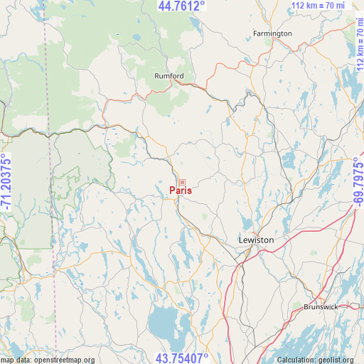
Paris GPS coordinates[2]
44° 15' 35.244" North, 70° 30' 2.232" West
| Map corner | latitude | longitude |
|---|---|---|
| Upper-left | 44.7612°, | -71.20375° |
| Center: | 44.25979°, | -70.50062° |
| Lower-right: | 43.75407°, | -69.7975° |
| Map W x H: | 112×112 km | = 69.6×69.6mi |
| max Lat: | 71.29058° ⇑10.6% North |
| Paris: | 44.25979° |
| min Lat: | ⇓89.4% South 19.06759° |
| min Long | Paris | max Long |
| -171.73463° | -70.50062° | -66.98998° |
| W 98.4%⇐ | ⇒1.6% E |
Elevation
Elevation of Paris is 247 m = 810 ft, and this is 47.8 m = 157 ft below average elevation for this country.
| Max E: |
3189 m = 10463 ft | 38.3% |
| Avg. | 294.8 m = 967 ft | |
| Paris | 247 m = 810 ft | |
Min E: |
-60 m = -197 ft | 61.7% |
See also: United States elevation on elevation.city.
Geographical zone
Paris is located in North temperate zone (between Tropic of Cancer and the Arctic Circle). Distance of this Northern Tropic circle is 2315.3 km =1438.7 mi to South.| Distance of | km | miles | from Paris |
|---|---|---|---|
| North Pole | 5085.8 | 3160.2 | to North |
| Arctic Circle | 2479.9 | 1540.9 | to North |
| Tropic Cancer | 2315.3 | 1438.7 | to South |
| Equator | 4921.2 | 3057.9 | to South |


Nearby cities:
15 places around Paris: (largest is in red/bold)
• Buckfield
11.3 km =7 mi,  72°
72°
• Greenwood
13.6 km =8.5 mi,  298°
298°
• Harrison
21.9 km =13.6 mi,  220°
220°
• Hartford
17.5 km =10.9 mi,  44°
44°
• Hebron
10.2 km =6.3 mi,  132°
132°
• Mechanic Falls
18.6 km =11.6 mi,  152°
152°
• Minot
24.1 km =15 mi,  143°
143°
• Norway
6.2 km =3.9 mi,  214°
214°
• Oxford
14.3 km =8.9 mi,  177°
177°
• Poland
23.7 km =14.7 mi,  158°
158°
• South Paris
4.1 km =2.5 mi,  194°
194°
• Sumner
15.5 km =9.6 mi,  18°
18°
• Turner
19.5 km =12.1 mi,  91°
91°
• West Paris
9.2 km =5.7 mi,  320°
320°
• Woodstock
15.4 km =9.6 mi,  326°
326°
Sources, notices
• [Note1] Compared only with cities in United States existing in our database
• [Src1] Map data: © OpenStreetMap contributors (CC-BY-SA)
• [Src2] Other city data from geonames.org with taken over terms of usage.
• [Src3] Geographical zone / Annual Mean Temperature by Robert A. Rohde @ Wikipedia
