Bessemer geodata
Bessemer (Michigan) is a seat of a second-order administrative division; located in United States in America/Menominee (GMT-5) time zone. With population of 1,770 people, there are 12667 cities with bigger population in this country. Compared to other cities in United States, 95.8% of cities are located further ↓South; 59.1% of cities are located further →East and 85.8% of cities have lower elevation than Bessemer. Note1


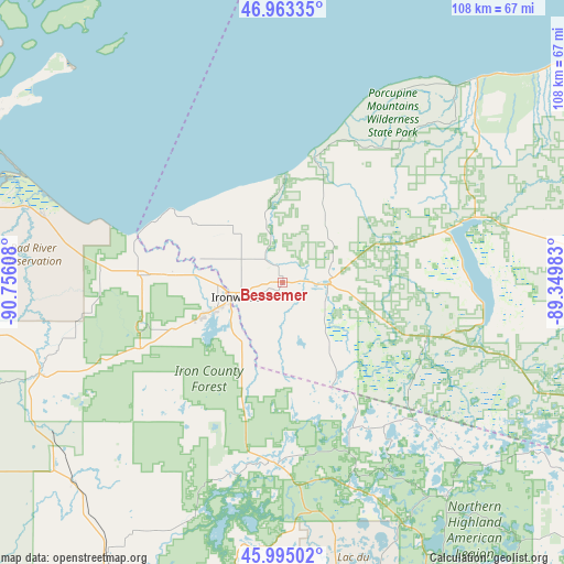
Bessemer GPS coordinates[2]
46° 28' 52.824" North, 90° 3' 10.62" West
| Map corner | latitude | longitude |
|---|---|---|
| Upper-left | 46.96335°, | -90.75608° |
| Center: | 46.48134°, | -90.05295° |
| Lower-right: | 45.99502°, | -89.34983° |
| Map W x H: | 107.7×107.7 km | = 66.9×66.9mi |
| max Lat: | 71.29058° ⇑4.2% North |
| Bessemer: | 46.48134° |
| min Lat: | ⇓95.8% South 19.06759° |
| min Long | Bessemer | max Long |
| -171.73463° | -90.05295° | -66.98998° |
| W 40.9%⇐ | ⇒59.1% E |
Elevation
Elevation of Bessemer is 440 m = 1444 ft, and this is 145.2 m = 476 ft above average elevation for this country.
| Max E: |
3189 m = 10463 ft | 14.2% |
| Bessemer | 440 m 1444 ft | |
| Avg. | 294.8 m = 967 ft | |
Min E: |
-60 m = -197 ft | 85.8% |
See also: United States elevation on elevation.city.
Geographical zone
Bessemer is located in North temperate zone (between Tropic of Cancer and the Arctic Circle). Distance of this North polar circle is 2232.9 km =1387.5 mi to North.| Distance of | km | miles | from Bessemer |
|---|---|---|---|
| North Pole | 4838.8 | 3006.7 | to North |
| Arctic Circle | 2232.9 | 1387.5 | to North |
| Tropic Cancer | 2562.3 | 1592.1 | to South |
| Equator | 5168.2 | 3211.4 | to South |


Nearby cities:
15 places around Bessemer: (largest is in red/bold)
• Ashland
64.7 km =40.2 mi,  281°
281°
• Eagle River
88.4 km =54.9 mi,  135°
135°
• Glidden
55.8 km =34.7 mi,  226°
226°
• Hurley
10.8 km =6.7 mi,  251°
251°
• Ironwood
9.5 km =5.9 mi, 251°
• Lac du Flambeau
58.2 km =36.2 mi,  167°
167°
• Mellen
49.7 km =30.9 mi, 249°
• Mercer
35.1 km =21.8 mi,  181°
181°
• Montreal
15.9 km =9.9 mi, 248°
• Ontonagon
71.1 km =44.2 mi,  52°
52°
• Park Falls
67.8 km =42.1 mi,  206°
206°
• Phillips
91.3 km =56.7 mi,  197°
197°
• Wakefield
8.7 km =5.4 mi,  94°
94°
• Washburn
67.8 km =42.1 mi,  288°
288°
• Woodruff
70.5 km =43.8 mi,  157°
157°
Sources, notices
• [Note1] Compared only with cities in United States existing in our database
• [Src1] Map data: © OpenStreetMap contributors (CC-BY-SA)
• [Src2] Other city data from geonames.org with taken over terms of usage.
• [Src3] Geographical zone / Annual Mean Temperature by Robert A. Rohde @ Wikipedia
