Ironwood geodata
Ironwood (Michigan) is a populated place; located in United States in America/Menominee (GMT-5) time zone. With population of 5,002 people, there are 7167 cities with bigger population in this country. Compared to other cities in United States, 95.8% of cities are located further ↓South; 59.5% of cities are located further →East and 86.7% of cities have lower elevation than Ironwood. Note1


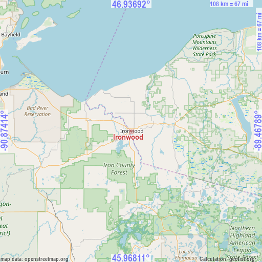
Ironwood GPS coordinates[2]
46° 27' 16.812" North, 90° 10' 15.636" West
| Map corner | latitude | longitude |
|---|---|---|
| Upper-left | 46.93692°, | -90.87414° |
| Center: | 46.45467°, | -90.17101° |
| Lower-right: | 45.96811°, | -89.46789° |
| Map W x H: | 107.7×107.7 km | = 66.9×66.9mi |
| max Lat: | 71.29058° ⇑4.2% North |
| Ironwood: | 46.45467° |
| min Lat: | ⇓95.8% South 19.06759° |
| min Long | Ironwood | max Long |
| -171.73463° | -90.17101° | -66.98998° |
| W 40.5%⇐ | ⇒59.5% E |
Elevation
Elevation of Ironwood is 459 m = 1506 ft, and this is 164.2 m = 539 ft above average elevation for this country.
| Max E: |
3189 m = 10463 ft | 13.3% |
| Ironwood | 459 m 1506 ft | |
| Avg. | 294.8 m = 967 ft | |
Min E: |
-60 m = -197 ft | 86.7% |
See also: United States elevation on elevation.city.
Geographical zone
Ironwood is located in North temperate zone (between Tropic of Cancer and the Arctic Circle). Distance of this North polar circle is 2235.9 km =1389.3 mi to North.| Distance of | km | miles | from Ironwood |
|---|---|---|---|
| North Pole | 4841.8 | 3008.6 | to North |
| Arctic Circle | 2235.9 | 1389.3 | to North |
| Tropic Cancer | 2559.4 | 1590.3 | to South |
| Equator | 5165.3 | 3209.6 | to South |


Nearby cities:
15 places around Ironwood: (largest is in red/bold)
• Ashland
56.6 km =35.2 mi,  285°
285°
• Bessemer
9.5 km =5.9 mi,  71°
71°
• Eagle River
93.1 km =57.8 mi,  129°
129°
• Glidden
47.4 km =29.5 mi,  221°
221°
• Hurley
1.3 km =0.8 mi,  244°
244°
• Lac du Flambeau
58 km =36 mi,  158°
158°
• Mellen
40.2 km =25 mi,  249°
249°
• Mercer
33.2 km =20.6 mi,  165°
165°
• Montreal
6.5 km =4 mi, 242°
• Ontonagon
80.1 km =49.8 mi,  54°
54°
• Park Falls
61.5 km =38.2 mi,  199°
199°
• Phillips
86.1 km =53.5 mi,  191°
191°
• Wakefield
17.8 km =11.1 mi,  82°
82°
• Washburn
60.4 km =37.5 mi, 293°
• Woodruff
71.9 km =44.7 mi,  149°
149°
Sources, notices
• [Note1] Compared only with cities in United States existing in our database
• [Src1] Map data: © OpenStreetMap contributors (CC-BY-SA)
• [Src2] Other city data from geonames.org with taken over terms of usage.
• [Src3] Geographical zone / Annual Mean Temperature by Robert A. Rohde @ Wikipedia
