Detroit geodata
Detroit (Michigan) is a seat of a second-order administrative division; located in United States in America/Detroit (GMT-4) time zone. With population of 677,116 people, there are 24 cities with bigger population in this country. Compared to other cities in United States, 78.4% of cities are located further ↓South; 61.9% of cities are located further ←West and 51.6% of cities have higher elevation than Detroit. Note1


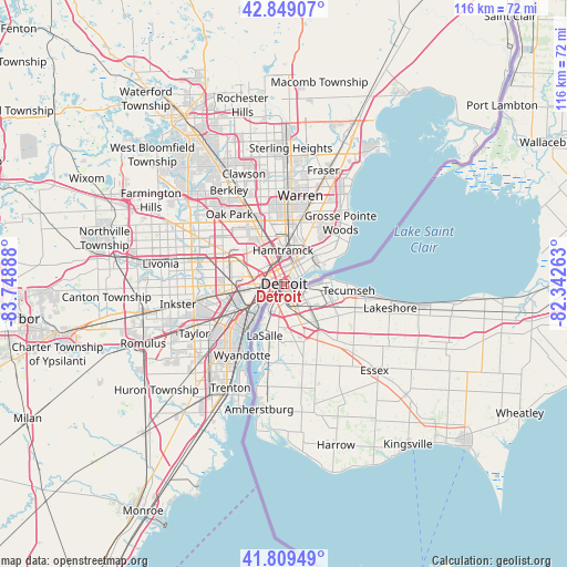
Detroit GPS coordinates[2]
42° 19' 53.148" North, 83° 2' 44.7" West
| Map corner | latitude | longitude |
|---|---|---|
| Upper-left | 42.84907°, | -83.74888° |
| Center: | 42.33143°, | -83.04575° |
| Lower-right: | 41.80949°, | -82.34263° |
| Map W x H: | 115.6×115.6 km | = 71.8×71.8mi |
| max Lat: | 71.29058° ⇑21.6% North |
| Detroit: | 42.33143° |
| min Lat: | ⇓78.4% South 19.06759° |
| min Long | Detroit | max Long |
| -171.73463° | -83.04575° | -66.98998° |
| W 61.9%⇐ | ⇒38.1% E |
Elevation
Elevation of Detroit is 192 m = 630 ft, and this is 102.8 m = 337 ft below average elevation for this country.
| Max E: |
3189 m = 10463 ft | 51.6% |
| Avg. | 294.8 m = 967 ft | |
| Detroit | 192 m = 630 ft | |
Min E: |
-60 m = -197 ft | 48.4% |
See also: Detroit elevation on elevation.city.
Geographical zone
Detroit is located in North temperate zone (between Tropic of Cancer and the Arctic Circle). Distance of this Northern Tropic circle is 2100.9 km =1305.4 mi to South.| Distance of | km | miles | from Detroit |
|---|---|---|---|
| North Pole | 5300.2 | 3293.4 | to North |
| Arctic Circle | 2694.4 | 1674.2 | to North |
| Tropic Cancer | 2100.9 | 1305.4 | to South |
| Equator | 4706.8 | 2924.7 | to South |


Nearby cities:
15 places around Detroit: (largest is in red/bold)
• Allen Park
15.9 km =9.9 mi,  238°
238°
• Dearborn
10.8 km =6.7 mi,  264°
264°
• Ecorse
12.7 km =7.9 mi,  220°
220°
• Ferndale
16.1 km =10 mi,  333°
333°
• Grosse Pointe
12.6 km =7.8 mi,  61°
61°
• Grosse Pointe Farms
15.3 km =9.5 mi, 55°
• Grosse Pointe Park
10.2 km =6.3 mi, 60°
• Hamtramck
6.8 km =4.2 mi,  357°
357°
• Harper Woods
15.1 km =9.4 mi,  41°
41°
• Hazel Park
15.3 km =9.5 mi,  341°
341°
• Highland Park
9.3 km =5.8 mi, 333°
• Lincoln Park
14.1 km =8.8 mi,  230°
230°
• Melvindale
12 km =7.5 mi, 242°
• River Rouge
9.7 km =6 mi, 228°
• Wyandotte
15.6 km =9.7 mi,  213°
213°
Sources, notices
• [Note1] Compared only with cities in United States existing in our database
• [Src1] Map data: © OpenStreetMap contributors (CC-BY-SA)
• [Src2] Other city data from geonames.org with taken over terms of usage.
• [Src3] Geographical zone / Annual Mean Temperature by Robert A. Rohde @ Wikipedia
