Dearborn geodata
Dearborn (Michigan) is a populated place; located in United States in America/Detroit (GMT-4) time zone. With population of 95,171 people, there are 374 cities with bigger population in this country. Compared to other cities in United States, 78.3% of cities are located further ↓South; 61.5% of cities are located further ←West and 54.2% of cities have higher elevation than Dearborn. Note1


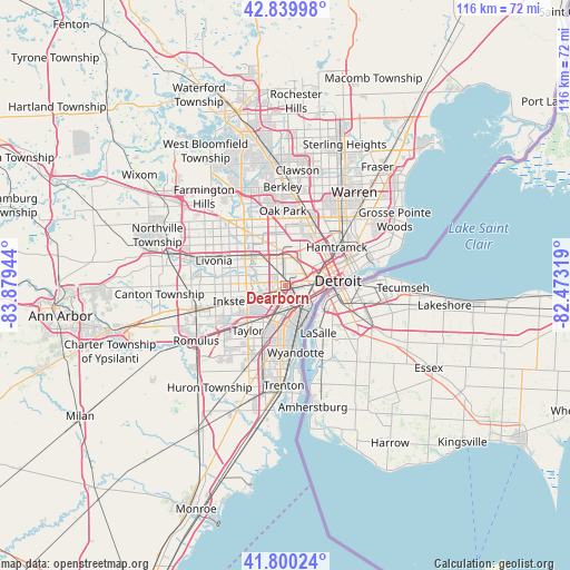
Dearborn GPS coordinates[2]
42° 19' 20.136" North, 83° 10' 34.716" West
| Map corner | latitude | longitude |
|---|---|---|
| Upper-left | 42.83998°, | -83.87944° |
| Center: | 42.32226°, | -83.17631° |
| Lower-right: | 41.80024°, | -82.47319° |
| Map W x H: | 115.6×115.6 km | = 71.8×71.8mi |
| max Lat: | 71.29058° ⇑21.7% North |
| Dearborn: | 42.32226° |
| min Lat: | ⇓78.3% South 19.06759° |
| min Long | Dearborn | max Long |
| -171.73463° | -83.17631° | -66.98998° |
| W 61.5%⇐ | ⇒38.5% E |
Elevation
Elevation of Dearborn is 183 m = 600 ft, and this is 111.8 m = 367 ft below average elevation for this country.
| Max E: |
3189 m = 10463 ft | 54.2% |
| Avg. | 294.8 m = 967 ft | |
| Dearborn | 183 m = 600 ft | |
Min E: |
-60 m = -197 ft | 45.8% |
See also: Dearborn elevation on elevation.city.
Geographical zone
Dearborn is located in North temperate zone (between Tropic of Cancer and the Arctic Circle). Distance of this Northern Tropic circle is 2099.9 km =1304.8 mi to South.| Distance of | km | miles | from Dearborn |
|---|---|---|---|
| North Pole | 5301.3 | 3294.1 | to North |
| Arctic Circle | 2695.4 | 1674.8 | to North |
| Tropic Cancer | 2099.9 | 1304.8 | to South |
| Equator | 4705.8 | 2924 | to South |


Nearby cities:
15 places around Dearborn: (largest is in red/bold)
• Allen Park
7.7 km =4.8 mi,  201°
201°
• Dearborn Heights
8.1 km =5 mi,  281°
281°
• Detroit
10.8 km =6.7 mi,  84°
84°
• Ecorse
9 km =5.6 mi,  163°
163°
• Garden City
12.7 km =7.9 mi,  271°
271°
• Hamtramck
13 km =8.1 mi,  52°
52°
• Highland Park
11.3 km =7 mi,  35°
35°
• Inkster
11.4 km =7.1 mi,  254°
254°
• Lincoln Park
8 km =5 mi,  181°
181°
• Melvindale
4.4 km =2.7 mi, 178°
• Redford
12 km =7.5 mi,  304°
304°
• River Rouge
6.4 km =4 mi,  147°
147°
• Southgate
12.1 km =7.5 mi,  186°
186°
• Taylor
11.9 km =7.4 mi,  220°
220°
• Wyandotte
12.2 km =7.6 mi,  169°
169°
Sources, notices
• [Note1] Compared only with cities in United States existing in our database
• [Src1] Map data: © OpenStreetMap contributors (CC-BY-SA)
• [Src2] Other city data from geonames.org with taken over terms of usage.
• [Src3] Geographical zone / Annual Mean Temperature by Robert A. Rohde @ Wikipedia
