Hart geodata
Hart (Michigan) is a seat of a second-order administrative division; located in United States in America/Detroit (GMT-4) time zone. With population of 2,098 people, there are 11626 cities with bigger population in this country. Compared to other cities in United States, 87.2% of cities are located further ↓South; 51.9% of cities are located further ←West and 53% of cities have lower elevation than Hart. Note1


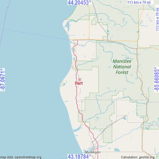
Hart GPS coordinates[2]
43° 41' 54.024" North, 86° 21' 50.292" West
| Map corner | latitude | longitude |
|---|---|---|
| Upper-left | 44.20453°, | -87.0671° |
| Center: | 43.69834°, | -86.36397° |
| Lower-right: | 43.18784°, | -85.66085° |
| Map W x H: | 113×113 km | = 70.2×70.2mi |
| max Lat: | 71.29058° ⇑12.8% North |
| Hart: | 43.69834° |
| min Lat: | ⇓87.2% South 19.06759° |
| min Long | Hart | max Long |
| -171.73463° | -86.36397° | -66.98998° |
| W 51.9%⇐ | ⇒48.1% E |
Elevation
Elevation of Hart is 210 m = 689 ft, and this is 84.8 m = 278 ft below average elevation for this country.
| Max E: |
3189 m = 10463 ft | 47% |
| Avg. | 294.8 m = 967 ft | |
| Hart | 210 m = 689 ft | |
Min E: |
-60 m = -197 ft | 53% |
See also: United States elevation on elevation.city.
Geographical zone
Hart is located in North temperate zone (between Tropic of Cancer and the Arctic Circle). Distance of this Northern Tropic circle is 2252.9 km =1399.9 mi to South.| Distance of | km | miles | from Hart |
|---|---|---|---|
| North Pole | 5148.3 | 3199 | to North |
| Arctic Circle | 2542.4 | 1579.8 | to North |
| Tropic Cancer | 2252.9 | 1399.9 | to South |
| Equator | 4858.8 | 3019.1 | to South |


Nearby cities:
15 places around Hart: (largest is in red/bold)
• Baldwin
46.9 km =29.1 mi,  61°
61°
• Fremont
42.6 km =26.5 mi,  127°
127°
• Hesperia
29.8 km =18.5 mi,  118°
118°
• Lakewood Club
37.3 km =23.2 mi,  167°
167°
• Ludington
29.4 km =18.3 mi,  346°
346°
• Montague
31.3 km =19.4 mi,  178°
178°
• Muskegon
52.4 km =32.6 mi, 169°
• North Muskegon
49.8 km =30.9 mi, 171°
• Pentwater
10.8 km =6.7 mi,  329°
329°
• Scottville
29.3 km =18.2 mi,  13°
13°
• Shelby
10 km =6.2 mi, 179°
• Twin Lake
40.6 km =25.2 mi,  156°
156°
• White Cloud
50.4 km =31.3 mi,  109°
109°
• Whitehall
32.1 km =19.9 mi, 177°
• Wolf Lake
53.4 km =33.2 mi, 157°
Sources, notices
• [Note1] Compared only with cities in United States existing in our database
• [Src1] Map data: © OpenStreetMap contributors (CC-BY-SA)
• [Src2] Other city data from geonames.org with taken over terms of usage.
• [Src3] Geographical zone / Annual Mean Temperature by Robert A. Rohde @ Wikipedia
