Trenton geodata
Trenton (Michigan) is a populated place; located in United States in America/Detroit (GMT-4) time zone. With population of 18,380 people, there are 2729 cities with bigger population in this country. Compared to other cities in United States, 76.9% of cities are located further ↓South; 61.5% of cities are located further ←West and 54.5% of cities have higher elevation than Trenton. Note1


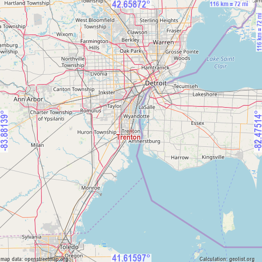
Trenton GPS coordinates[2]
42° 8' 22.164" North, 83° 10' 41.736" West
| Map corner | latitude | longitude |
|---|---|---|
| Upper-left | 42.65872°, | -83.88139° |
| Center: | 42.13949°, | -83.17826° |
| Lower-right: | 41.61597°, | -82.47514° |
| Map W x H: | 115.9×115.9 km | = 72×72mi |
| max Lat: | 71.29058° ⇑23.1% North |
| Trenton: | 42.13949° |
| min Lat: | ⇓76.9% South 19.06759° |
| min Long | Trenton | max Long |
| -171.73463° | -83.17826° | -66.98998° |
| W 61.5%⇐ | ⇒38.5% E |
Elevation
Elevation of Trenton is 182 m = 597 ft, and this is 112.8 m = 370 ft below average elevation for this country.
| Max E: |
3189 m = 10463 ft | 54.5% |
| Avg. | 294.8 m = 967 ft | |
| Trenton | 182 m = 597 ft | |
Min E: |
-60 m = -197 ft | 45.5% |
See also: United States elevation on elevation.city.
Geographical zone
Trenton is located in North temperate zone (between Tropic of Cancer and the Arctic Circle). Distance of this Northern Tropic circle is 2079.6 km =1292.2 mi to South.| Distance of | km | miles | from Trenton |
|---|---|---|---|
| North Pole | 5321.6 | 3306.7 | to North |
| Arctic Circle | 2715.7 | 1687.5 | to North |
| Tropic Cancer | 2079.6 | 1292.2 | to South |
| Equator | 4685.5 | 2911.4 | to South |


Nearby cities:
15 places around Trenton: (largest is in red/bold)
• Allen Park
13.4 km =8.3 mi,  348°
348°
• Ecorse
12 km =7.5 mi,  12°
12°
• Flat Rock
10.5 km =6.5 mi,  242°
242°
• Gibraltar
5 km =3.1 mi,  190°
190°
• Grosse Ile
3 km =1.9 mi,  112°
112°
• Lincoln Park
12.4 km =7.7 mi,  359°
359°
• Melvindale
15.9 km =9.9 mi,  0°
0°
• River Rouge
15.3 km =9.5 mi, 13°
• Riverview
3.9 km =2.4 mi, 358°
• Rockwood
9.5 km =5.9 mi,  216°
216°
• South Rockwood
10.8 km =6.7 mi, 219°
• Southgate
8.4 km =5.2 mi, 351°
• Taylor
13.6 km =8.5 mi,  326°
326°
• Woodhaven
5.2 km =3.2 mi,  269°
269°
• Wyandotte
8.6 km =5.3 mi,  15°
15°
Sources, notices
• [Note1] Compared only with cities in United States existing in our database
• [Src1] Map data: © OpenStreetMap contributors (CC-BY-SA)
• [Src2] Other city data from geonames.org with taken over terms of usage.
• [Src3] Geographical zone / Annual Mean Temperature by Robert A. Rohde @ Wikipedia
