Taylor geodata
Taylor (Michigan) is a populated place; located in United States in America/Detroit (GMT-4) time zone. With population of 61,568 people, there are 712 cities with bigger population in this country. Compared to other cities in United States, 77.7% of cities are located further ↓South; 61.2% of cities are located further ←West and 52.5% of cities have higher elevation than Taylor. Note1


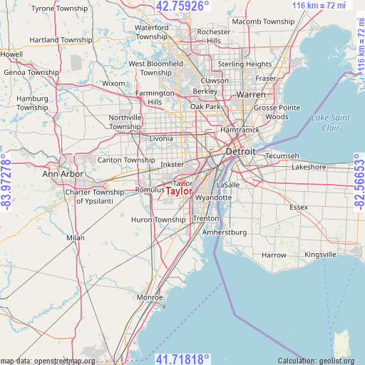
Taylor GPS coordinates[2]
42° 14' 27.132" North, 83° 16' 10.74" West
| Map corner | latitude | longitude |
|---|---|---|
| Upper-left | 42.75926°, | -83.97278° |
| Center: | 42.24087°, | -83.26965° |
| Lower-right: | 41.71818°, | -82.56653° |
| Map W x H: | 115.8×115.8 km | = 72×72mi |
| max Lat: | 71.29058° ⇑22.3% North |
| Taylor: | 42.24087° |
| min Lat: | ⇓77.7% South 19.06759° |
| min Long | Taylor | max Long |
| -171.73463° | -83.26965° | -66.98998° |
| W 61.2%⇐ | ⇒38.8% E |
Elevation
Elevation of Taylor is 189 m = 620 ft, and this is 105.8 m = 347 ft below average elevation for this country.
| Max E: |
3189 m = 10463 ft | 52.5% |
| Avg. | 294.8 m = 967 ft | |
| Taylor | 189 m = 620 ft | |
Min E: |
-60 m = -197 ft | 47.5% |
See also: Taylor elevation on elevation.city.
Geographical zone
Taylor is located in North temperate zone (between Tropic of Cancer and the Arctic Circle). Distance of this Northern Tropic circle is 2090.8 km =1299.2 mi to South.| Distance of | km | miles | from Taylor |
|---|---|---|---|
| North Pole | 5310.3 | 3299.7 | to North |
| Arctic Circle | 2704.4 | 1680.4 | to North |
| Tropic Cancer | 2090.8 | 1299.2 | to South |
| Equator | 4696.7 | 2918.4 | to South |


Nearby cities:
15 places around Taylor: (largest is in red/bold)
• Allen Park
5.2 km =3.2 mi,  68°
68°
• Dearborn
11.9 km =7.4 mi,  40°
40°
• Dearborn Heights
10.7 km =6.6 mi,  358°
358°
• Ecorse
10.2 km =6.3 mi,  87°
87°
• Garden City
10.7 km =6.6 mi,  331°
331°
• Inkster
6.8 km =4.2 mi, 330°
• Lincoln Park
7.6 km =4.7 mi,  81°
81°
• Melvindale
9 km =5.6 mi,  59°
59°
• River Rouge
11.7 km =7.3 mi, 72°
• Riverview
10.5 km =6.5 mi,  134°
134°
• Romulus
10.7 km =6.6 mi,  258°
258°
• Southgate
6.9 km =4.3 mi,  115°
115°
• Wayne
10.6 km =6.6 mi,  295°
295°
• Woodhaven
11.6 km =7.2 mi,  168°
168°
• Wyandotte
10.3 km =6.4 mi,  106°
106°
Sources, notices
• [Note1] Compared only with cities in United States existing in our database
• [Src1] Map data: © OpenStreetMap contributors (CC-BY-SA)
• [Src2] Other city data from geonames.org with taken over terms of usage.
• [Src3] Geographical zone / Annual Mean Temperature by Robert A. Rohde @ Wikipedia
