Albany geodata
Albany (Minnesota) is a populated place; located in United States in America/Chicago (GMT-5) time zone. With population of 2,647 people, there are 10291 cities with bigger population in this country. Compared to other cities in United States, 94.4% of cities are located further ↓South; 70% of cities are located further →East and 81.3% of cities have lower elevation than Albany. Note1


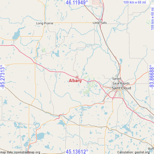
Albany GPS coordinates[2]
45° 37' 47.856" North, 94° 34' 12" West
| Map corner | latitude | longitude |
|---|---|---|
| Upper-left | 46.11949°, | -95.27313° |
| Center: | 45.62996°, | -94.57° |
| Lower-right: | 45.13612°, | -93.86688° |
| Map W x H: | 109.3×109.3 km | = 67.9×67.9mi |
| max Lat: | 71.29058° ⇑5.6% North |
| Albany: | 45.62996° |
| min Lat: | ⇓94.4% South 19.06759° |
| min Long | Albany | max Long |
| -171.73463° | -94.57° | -66.98998° |
| W 30%⇐ | ⇒70% E |
Elevation
Elevation of Albany is 368 m = 1207 ft, and this is 73.2 m = 240 ft above average elevation for this country.
| Max E: |
3189 m = 10463 ft | 18.7% |
| Albany | 368 m 1207 ft | |
| Avg. | 294.8 m = 967 ft | |
Min E: |
-60 m = -197 ft | 81.3% |
See also: United States elevation on elevation.city.
Geographical zone
Albany is located in North temperate zone (between Tropic of Cancer and the Arctic Circle). Distance of this North polar circle is 2327.6 km =1446.3 mi to North.| Distance of | km | miles | from Albany |
|---|---|---|---|
| North Pole | 4933.5 | 3065.5 | to North |
| Arctic Circle | 2327.6 | 1446.3 | to North |
| Tropic Cancer | 2467.7 | 1533.4 | to South |
| Equator | 5073.6 | 3152.6 | to South |


Nearby cities:
15 places around Albany: (largest is in red/bold)
• Avon
9.5 km =5.9 mi,  104°
104°
• Cold Spring
22.3 km =13.9 mi,  150°
150°
• Collegeville
16.6 km =10.3 mi, 103°
• Freeport
10 km =6.2 mi,  291°
291°
• Holdingford
13.7 km =8.5 mi,  34°
34°
• Melrose
19.1 km =11.9 mi, 285°
• Paynesville
29.9 km =18.6 mi,  201°
201°
• Pleasant Lake
26.5 km =16.5 mi,  123°
123°
• Rice
30.4 km =18.9 mi,  63°
63°
• Richmond
20 km =12.4 mi,  168°
168°
• Rockville
25 km =15.5 mi,  134°
134°
• Saint Joseph
20.9 km =13 mi,  110°
110°
• Saint Stephen
24.3 km =15.1 mi,  70°
70°
• Sartell
28.2 km =17.5 mi,  91°
91°
• Waite Park
28.1 km =17.5 mi, 106°
Sources, notices
• [Note1] Compared only with cities in United States existing in our database
• [Src1] Map data: © OpenStreetMap contributors (CC-BY-SA)
• [Src2] Other city data from geonames.org with taken over terms of usage.
• [Src3] Geographical zone / Annual Mean Temperature by Robert A. Rohde @ Wikipedia
