Collegeville geodata
Collegeville (Minnesota) is a populated place; located in United States in America/Chicago (GMT-5) time zone. With population of 3,516 people, there are 8838 cities with bigger population in this country. Compared to other cities in United States, 94.3% of cities are located further ↓South; 69.6% of cities are located further →East and 77.6% of cities have lower elevation than Collegeville. Note1
Administrative division(s):
- Level 1: Minnesota
- Level 2: Stearns County
- Level 3: Township of Saint Wendel


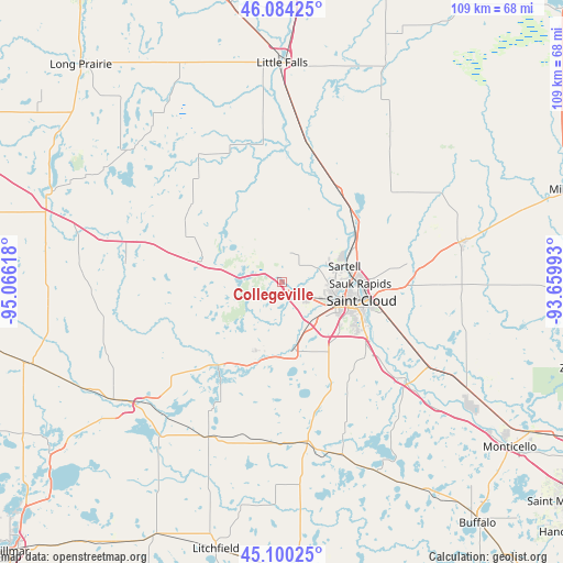
Collegeville GPS coordinates[2]
45° 35' 39.876" North, 94° 21' 46.98" West
| Map corner | latitude | longitude |
|---|---|---|
| Upper-left | 46.08425°, | -95.06618° |
| Center: | 45.59441°, | -94.36305° |
| Lower-right: | 45.10025°, | -93.65993° |
| Map W x H: | 109.4×109.4 km | = 68×68mi |
| max Lat: | 71.29058° ⇑5.7% North |
| Collegeville: | 45.59441° |
| min Lat: | ⇓94.3% South 19.06759° |
| min Long | Collegeville | max Long |
| -171.73463° | -94.36305° | -66.98998° |
| W 30.4%⇐ | ⇒69.6% E |
Elevation
Elevation of Collegeville is 333 m = 1093 ft, and this is 38.2 m = 125 ft above average elevation for this country.
| Max E: |
3189 m = 10463 ft | 22.4% |
| Collegeville | 333 m 1093 ft | |
| Avg. | 294.8 m = 967 ft | |
Min E: |
-60 m = -197 ft | 77.6% |
See also: United States elevation on elevation.city.
Geographical zone
Collegeville is located in North temperate zone (between Tropic of Cancer and the Arctic Circle). Distance of this North polar circle is 2331.6 km =1448.8 mi to North.| Distance of | km | miles | from Collegeville |
|---|---|---|---|
| North Pole | 4937.4 | 3068 | to North |
| Arctic Circle | 2331.6 | 1448.8 | to North |
| Tropic Cancer | 2463.7 | 1530.9 | to South |
| Equator | 5069.6 | 3150.1 | to South |


Nearby cities:
15 places around Collegeville: (largest is in red/bold)
• Albany
16.6 km =10.3 mi,  283°
283°
• Avon
7.1 km =4.4 mi, 283°
• Cold Spring
16.2 km =10.1 mi,  198°
198°
• Holdingford
17.3 km =10.7 mi,  331°
331°
• Pleasant Lake
12.3 km =7.6 mi,  151°
151°
• Rice
20.7 km =12.9 mi,  32°
32°
• Richmond
19.7 km =12.2 mi,  217°
217°
• Rockville
13.7 km =8.5 mi,  172°
172°
• Saint Augusta
19.9 km =12.4 mi,  139°
139°
• Saint Cloud
16 km =9.9 mi,  103°
103°
• Saint Joseph
4.8 km =3 mi,  133°
133°
• Saint Stephen
13.9 km =8.6 mi, 29°
• Sartell
12.5 km =7.8 mi,  76°
76°
• Sauk Rapids
15.3 km =9.5 mi,  91°
91°
• Waite Park
11.6 km =7.2 mi,  110°
110°
Sources, notices
• [Note1] Compared only with cities in United States existing in our database
• [Src1] Map data: © OpenStreetMap contributors (CC-BY-SA)
• [Src2] Other city data from geonames.org with taken over terms of usage.
• [Src3] Geographical zone / Annual Mean Temperature by Robert A. Rohde @ Wikipedia
