Hugo geodata
Hugo (Minnesota) is a populated place; located in United States in America/Chicago (GMT-5) time zone. With population of 14,388 people, there are 3361 cities with bigger population in this country. Compared to other cities in United States, 93.1% of cities are located further ↓South; 66.2% of cities are located further →East and 69.3% of cities have lower elevation than Hugo. Note1


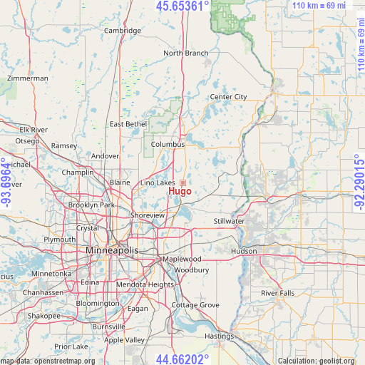
Hugo GPS coordinates[2]
45° 9' 35.892" North, 92° 59' 35.772" West
| Map corner | latitude | longitude |
|---|---|---|
| Upper-left | 45.65361°, | -93.6964° |
| Center: | 45.15997°, | -92.99327° |
| Lower-right: | 44.66202°, | -92.29015° |
| Map W x H: | 110.3×110.3 km | = 68.5×68.5mi |
| max Lat: | 71.29058° ⇑6.9% North |
| Hugo: | 45.15997° |
| min Lat: | ⇓93.1% South 19.06759° |
| min Long | Hugo | max Long |
| -171.73463° | -92.99327° | -66.98998° |
| W 33.8%⇐ | ⇒66.2% E |
Elevation
Elevation of Hugo is 282 m = 925 ft, and this is 12.8 m = 42 ft below average elevation for this country.
| Max E: |
3189 m = 10463 ft | 30.7% |
| Avg. | 294.8 m = 967 ft | |
| Hugo | 282 m = 925 ft | |
Min E: |
-60 m = -197 ft | 69.3% |
See also: United States elevation on elevation.city.
Geographical zone
Hugo is located in North temperate zone (between Tropic of Cancer and the Arctic Circle). Distance of this North polar circle is 2379.9 km =1478.8 mi to North.| Distance of | km | miles | from Hugo |
|---|---|---|---|
| North Pole | 4985.7 | 3098 | to North |
| Arctic Circle | 2379.9 | 1478.8 | to North |
| Tropic Cancer | 2415.4 | 1500.9 | to South |
| Equator | 5021.3 | 3120.1 | to South |


Nearby cities:
15 places around Hugo: (largest is in red/bold)
• Birchwood
11.1 km =6.9 mi,  172°
172°
• Centerville
4.9 km =3 mi,  273°
273°
• Circle Pines
12.5 km =7.8 mi,  264°
264°
• Columbus
12.5 km =7.8 mi,  339°
339°
• Dellwood
8 km =5 mi, 168°
• Forest Lake
13.2 km =8.2 mi,  2°
2°
• Grant
10.6 km =6.6 mi,  142°
142°
• Lexington
13.5 km =8.4 mi, 261°
• Lino Lakes
7.5 km =4.7 mi, 270°
• Mahtomedi
10.6 km =6.6 mi,  161°
161°
• North Oaks
9.3 km =5.8 mi,  226°
226°
• North Saint Paul
16.4 km =10.2 mi,  179°
179°
• Shoreview
15.1 km =9.4 mi, 233°
• Vadnais Heights
13 km =8.1 mi,  209°
209°
• White Bear Lake
8.5 km =5.3 mi,  188°
188°
Sources, notices
• [Note1] Compared only with cities in United States existing in our database
• [Src1] Map data: © OpenStreetMap contributors (CC-BY-SA)
• [Src2] Other city data from geonames.org with taken over terms of usage.
• [Src3] Geographical zone / Annual Mean Temperature by Robert A. Rohde @ Wikipedia
