Isanti geodata
Isanti (Minnesota) is a populated place; located in United States in America/Chicago (GMT-5) time zone. With population of 5,464 people, there are 6794 cities with bigger population in this country. Compared to other cities in United States, 94% of cities are located further ↓South; 66.9% of cities are located further →East and 69.5% of cities have lower elevation than Isanti. Note1


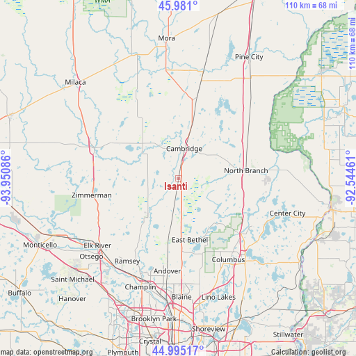
Isanti GPS coordinates[2]
45° 29' 24.864" North, 93° 14' 51.828" West
| Map corner | latitude | longitude |
|---|---|---|
| Upper-left | 45.981°, | -93.95086° |
| Center: | 45.49024°, | -93.24773° |
| Lower-right: | 44.99517°, | -92.54461° |
| Map W x H: | 109.6×109.6 km | = 68.1×68.1mi |
| max Lat: | 71.29058° ⇑6% North |
| Isanti: | 45.49024° |
| min Lat: | ⇓94% South 19.06759° |
| min Long | Isanti | max Long |
| -171.73463° | -93.24773° | -66.98998° |
| W 33.1%⇐ | ⇒66.9% E |
Elevation
Elevation of Isanti is 283 m = 928 ft, and this is 11.8 m = 39 ft below average elevation for this country.
| Max E: |
3189 m = 10463 ft | 30.5% |
| Avg. | 294.8 m = 967 ft | |
| Isanti | 283 m = 928 ft | |
Min E: |
-60 m = -197 ft | 69.5% |
See also: United States elevation on elevation.city.
Geographical zone
Isanti is located in North temperate zone (between Tropic of Cancer and the Arctic Circle). Distance of this North polar circle is 2343.1 km =1455.9 mi to North.| Distance of | km | miles | from Isanti |
|---|---|---|---|
| North Pole | 4949 | 3075.2 | to North |
| Arctic Circle | 2343.1 | 1455.9 | to North |
| Tropic Cancer | 2452.1 | 1523.7 | to South |
| Equator | 5058 | 3142.9 | to South |


Nearby cities:
15 places around Isanti: (largest is in red/bold)
• Braham
26.5 km =16.5 mi,  13°
13°
• Branch
22.3 km =13.9 mi,  91°
91°
• Cambridge
9.4 km =5.8 mi, 11°
• East Bethel
19.3 km =12 mi,  169°
169°
• Ham Lake
26.7 km =16.6 mi,  180°
180°
• Harris
23.8 km =14.8 mi,  63°
63°
• Martin Lake
17 km =10.6 mi,  135°
135°
• North Branch
21 km =13 mi,  83°
83°
• Nowthen
25 km =15.5 mi,  223°
223°
• Oak Grove
17.7 km =11 mi,  200°
200°
• Princeton
27.5 km =17.1 mi,  288°
288°
• Saint Francis
14.4 km =8.9 mi, 217°
• Stacy
22.7 km =14.1 mi,  116°
116°
• Wyoming
26 km =16.2 mi,  131°
131°
• Zimmerman
27.2 km =16.9 mi,  258°
258°
Sources, notices
• [Note1] Compared only with cities in United States existing in our database
• [Src1] Map data: © OpenStreetMap contributors (CC-BY-SA)
• [Src2] Other city data from geonames.org with taken over terms of usage.
• [Src3] Geographical zone / Annual Mean Temperature by Robert A. Rohde @ Wikipedia
