Wyoming geodata
Wyoming (Minnesota) is a populated place; located in United States in America/Chicago (GMT-5) time zone. With population of 7,813 people, there are 5378 cities with bigger population in this country. Compared to other cities in United States, 93.5% of cities are located further ↓South; 66.2% of cities are located further →East and 67.2% of cities have lower elevation than Wyoming. Note1


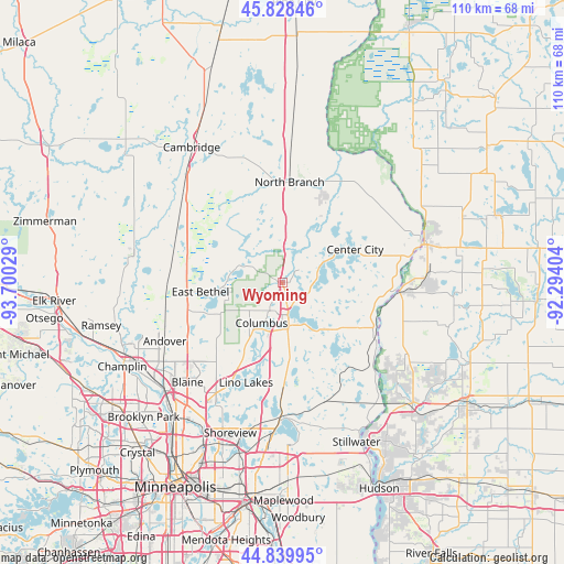
Wyoming GPS coordinates[2]
45° 20' 10.896" North, 92° 59' 49.776" West
| Map corner | latitude | longitude |
|---|---|---|
| Upper-left | 45.82846°, | -93.70029° |
| Center: | 45.33636°, | -92.99716° |
| Lower-right: | 44.83995°, | -92.29404° |
| Map W x H: | 109.9×109.9 km | = 68.3×68.3mi |
| max Lat: | 71.29058° ⇑6.5% North |
| Wyoming: | 45.33636° |
| min Lat: | ⇓93.5% South 19.06759° |
| min Long | Wyoming | max Long |
| -171.73463° | -92.99716° | -66.98998° |
| W 33.8%⇐ | ⇒66.2% E |
Elevation
Elevation of Wyoming is 272 m = 892 ft, and this is 22.8 m = 75 ft below average elevation for this country.
| Max E: |
3189 m = 10463 ft | 32.8% |
| Avg. | 294.8 m = 967 ft | |
| Wyoming | 272 m = 892 ft | |
Min E: |
-60 m = -197 ft | 67.2% |
See also: United States elevation on elevation.city.
Geographical zone
Wyoming is located in North temperate zone (between Tropic of Cancer and the Arctic Circle). Distance of this North polar circle is 2360.2 km =1466.6 mi to North.| Distance of | km | miles | from Wyoming |
|---|---|---|---|
| North Pole | 4966.1 | 3085.8 | to North |
| Arctic Circle | 2360.2 | 1466.6 | to North |
| Tropic Cancer | 2435 | 1513 | to South |
| Equator | 5040.9 | 3132.3 | to South |


Nearby cities:
15 places around Wyoming: (largest is in red/bold)
• Branch
16.8 km =10.4 mi,  9°
9°
• Center City
15.5 km =9.6 mi,  65°
65°
• Centerville
19.8 km =12.3 mi,  193°
193°
• Chisago City
9.3 km =5.8 mi,  63°
63°
• Columbus
8.9 km =5.5 mi,  207°
207°
• East Bethel
16.2 km =10.1 mi,  263°
263°
• Forest Lake
6.5 km =4 mi,  171°
171°
• Hugo
19.6 km =12.2 mi,  179°
179°
• Lindstrom
13.1 km =8.1 mi, 63°
• Lino Lakes
20.9 km =13 mi,  200°
200°
• Martin Lake
9.1 km =5.7 mi,  303°
303°
• North Branch
19.5 km =12.1 mi,  3°
3°
• Scandia
17.6 km =10.9 mi,  121°
121°
• Shafer
20.3 km =12.6 mi, 73°
• Stacy
6.9 km =4.3 mi, 6°
Sources, notices
• [Note1] Compared only with cities in United States existing in our database
• [Src1] Map data: © OpenStreetMap contributors (CC-BY-SA)
• [Src2] Other city data from geonames.org with taken over terms of usage.
• [Src3] Geographical zone / Annual Mean Temperature by Robert A. Rohde @ Wikipedia
