Maple Grove geodata
Maple Grove (Minnesota) is a populated place; located in United States in America/Chicago (GMT-5) time zone. With population of 68,385 people, there are 611 cities with bigger population in this country. Compared to other cities in United States, 92.9% of cities are located further ↓South; 67.4% of cities are located further →East and 70.4% of cities have lower elevation than Maple Grove. Note1
Administrative division(s):
- Level 1: Minnesota
- Level 2: Hennepin County
- Level 3: City of Maple Grove


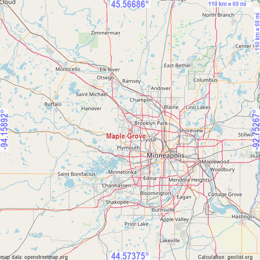
Maple Grove GPS coordinates[2]
45° 4' 20.856" North, 93° 27' 20.844" West
| Map corner | latitude | longitude |
|---|---|---|
| Upper-left | 45.56686°, | -94.15892° |
| Center: | 45.07246°, | -93.45579° |
| Lower-right: | 44.57375°, | -92.75267° |
| Map W x H: | 110.4×110.4 km | = 68.6×68.6mi |
| max Lat: | 71.29058° ⇑7.1% North |
| Maple Grove: | 45.07246° |
| min Lat: | ⇓92.9% South 19.06759° |
| min Long | Maple Grove | max Long |
| -171.73463° | -93.45579° | -66.98998° |
| W 32.6%⇐ | ⇒67.4% E |
Elevation
Elevation of Maple Grove is 288 m = 945 ft, and this is 6.8 m = 22 ft below average elevation for this country.
| Max E: |
3189 m = 10463 ft | 29.6% |
| Avg. | 294.8 m = 967 ft | |
| Maple Grove | 288 m = 945 ft | |
Min E: |
-60 m = -197 ft | 70.4% |
See also: Maple Grove elevation on elevation.city.
Geographical zone
Maple Grove is located in North temperate zone (between Tropic of Cancer and the Arctic Circle). Distance of this North polar circle is 2389.6 km =1484.8 mi to North.| Distance of | km | miles | from Maple Grove |
|---|---|---|---|
| North Pole | 4995.5 | 3104.1 | to North |
| Arctic Circle | 2389.6 | 1484.8 | to North |
| Tropic Cancer | 2405.7 | 1494.8 | to South |
| Equator | 5011.6 | 3114.1 | to South |


Nearby cities:
15 places around Maple Grove: (largest is in red/bold)
• Brooklyn Center
9.7 km =6 mi,  87°
87°
• Brooklyn Park
8.2 km =5.1 mi,  72°
72°
• Champlin
13.7 km =8.5 mi,  19°
19°
• Coon Rapids
14.2 km =8.8 mi, 68°
• Corcoran
7.6 km =4.7 mi,  289°
289°
• Crystal
8.7 km =5.4 mi,  120°
120°
• Golden Valley
10.9 km =6.8 mi,  129°
129°
• Long Lake
13.2 km =8.2 mi,  223°
223°
• Medina
10.8 km =6.7 mi,  247°
247°
• New Hope
6.6 km =4.1 mi, 125°
• Osseo
6.7 km =4.2 mi,  38°
38°
• Plymouth
6.9 km =4.3 mi,  179°
179°
• Robbinsdale
10.2 km =6.3 mi, 115°
• Wayzata
11.6 km =7.2 mi,  200°
200°
• West Coon Rapids
12.8 km =8 mi, 40°
Sources, notices
• [Note1] Compared only with cities in United States existing in our database
• [Src1] Map data: © OpenStreetMap contributors (CC-BY-SA)
• [Src2] Other city data from geonames.org with taken over terms of usage.
• [Src3] Geographical zone / Annual Mean Temperature by Robert A. Rohde @ Wikipedia
