Plymouth geodata
Plymouth (Minnesota) is a populated place; located in United States in America/Chicago (GMT-5) time zone. With population of 75,907 people, there are 532 cities with bigger population in this country. Compared to other cities in United States, 92.6% of cities are located further ↓South; 67.4% of cities are located further →East and 71.3% of cities have lower elevation than Plymouth. Note1


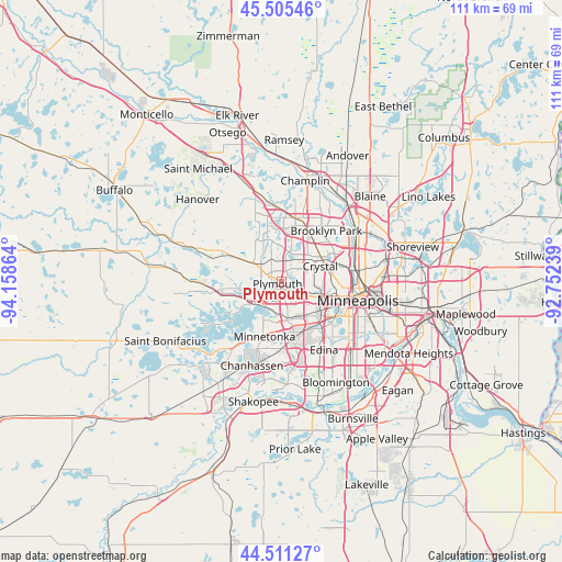
Plymouth GPS coordinates[2]
45° 0' 37.872" North, 93° 27' 19.836" West
| Map corner | latitude | longitude |
|---|---|---|
| Upper-left | 45.50546°, | -94.15864° |
| Center: | 45.01052°, | -93.45551° |
| Lower-right: | 44.51127°, | -92.75239° |
| Map W x H: | 110.5×110.5 km | = 68.7×68.7mi |
| max Lat: | 71.29058° ⇑7.4% North |
| Plymouth: | 45.01052° |
| min Lat: | ⇓92.6% South 19.06759° |
| min Long | Plymouth | max Long |
| -171.73463° | -93.45551° | -66.98998° |
| W 32.6%⇐ | ⇒67.4% E |
Elevation
Elevation of Plymouth is 292 m = 958 ft, and this is 2.8 m = 9 ft below average elevation for this country.
| Max E: |
3189 m = 10463 ft | 28.7% |
| Avg. | 294.8 m = 967 ft | |
| Plymouth | 292 m = 958 ft | |
Min E: |
-60 m = -197 ft | 71.3% |
See also: Plymouth elevation on elevation.city.
Geographical zone
Plymouth is located in North temperate zone (between Tropic of Cancer and the Arctic Circle). Distance of this North polar circle is 2396.5 km =1489.1 mi to North.| Distance of | km | miles | from Plymouth |
|---|---|---|---|
| North Pole | 5002.4 | 3108.3 | to North |
| Arctic Circle | 2396.5 | 1489.1 | to North |
| Tropic Cancer | 2398.8 | 1490.5 | to South |
| Equator | 5004.7 | 3109.8 | to South |


Nearby cities:
15 places around Plymouth: (largest is in red/bold)
• Brooklyn Park
12.1 km =7.5 mi,  39°
39°
• Corcoran
11.9 km =7.4 mi,  322°
322°
• Crystal
7.9 km =4.9 mi,  71°
71°
• Deephaven
10.4 km =6.5 mi,  210°
210°
• Golden Valley
8.4 km =5.2 mi,  90°
90°
• Hopkins
9.5 km =5.9 mi,  183°
183°
• Long Lake
9.5 km =5.9 mi,  253°
253°
• Maple Grove
6.9 km =4.3 mi,  359°
359°
• Medina
10.3 km =6.4 mi,  285°
285°
• Minnetonka
11.4 km =7.1 mi,  199°
199°
• Minnetonka Mills
7.8 km =4.8 mi,  172°
172°
• New Hope
6.2 km =3.9 mi,  60°
60°
• Robbinsdale
9.5 km =5.9 mi,  75°
75°
• Saint Louis Park
10.9 km =6.8 mi,  129°
129°
• Wayzata
5.7 km =3.5 mi,  224°
224°
Sources, notices
• [Note1] Compared only with cities in United States existing in our database
• [Src1] Map data: © OpenStreetMap contributors (CC-BY-SA)
• [Src2] Other city data from geonames.org with taken over terms of usage.
• [Src3] Geographical zone / Annual Mean Temperature by Robert A. Rohde @ Wikipedia
