Olivia geodata
Olivia (Minnesota) is a seat of a second-order administrative division; located in United States in America/Chicago (GMT-5) time zone. With population of 2,356 people, there are 10957 cities with bigger population in this country. Compared to other cities in United States, 91.5% of cities are located further ↓South; 71.1% of cities are located further →East and 77.2% of cities have lower elevation than Olivia. Note1


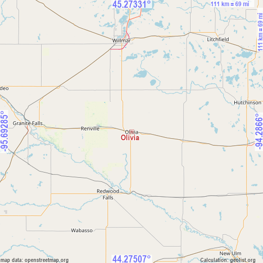
Olivia GPS coordinates[2]
44° 46' 34.86" North, 94° 59' 22.992" West
| Map corner | latitude | longitude |
|---|---|---|
| Upper-left | 45.27331°, | -95.69285° |
| Center: | 44.77635°, | -94.98972° |
| Lower-right: | 44.27507°, | -94.2866° |
| Map W x H: | 111×111 km | = 69×69mi |
| max Lat: | 71.29058° ⇑8.5% North |
| Olivia: | 44.77635° |
| min Lat: | ⇓91.5% South 19.06759° |
| min Long | Olivia | max Long |
| -171.73463° | -94.98972° | -66.98998° |
| W 28.9%⇐ | ⇒71.1% E |
Elevation
Elevation of Olivia is 329 m = 1079 ft, and this is 34.2 m = 112 ft above average elevation for this country.
| Max E: |
3189 m = 10463 ft | 22.8% |
| Olivia | 329 m 1079 ft | |
| Avg. | 294.8 m = 967 ft | |
Min E: |
-60 m = -197 ft | 77.2% |
See also: United States elevation on elevation.city.
Geographical zone
Olivia is located in North temperate zone (between Tropic of Cancer and the Arctic Circle). Distance of this Northern Tropic circle is 2372.7 km =1474.3 mi to South.| Distance of | km | miles | from Olivia |
|---|---|---|---|
| North Pole | 5028.4 | 3124.5 | to North |
| Arctic Circle | 2422.5 | 1505.3 | to North |
| Tropic Cancer | 2372.7 | 1474.3 | to South |
| Equator | 4978.7 | 3093.6 | to South |


Nearby cities:
15 places around Olivia: (largest is in red/bold)
• Atwater
43.6 km =27.1 mi,  22°
22°
• Bird Island
7.5 km =4.7 mi,  97°
97°
• Buffalo Lake
29.8 km =18.5 mi, 98°
• Clara City
35.7 km =22.2 mi,  303°
303°
• Fairfax
34.8 km =21.6 mi,  142°
142°
• Granite Falls
44 km =27.3 mi,  274°
274°
• Hector
21.9 km =13.6 mi, 99°
• Morgan
40.3 km =25 mi,  172°
172°
• Pennock
43.9 km =27.3 mi,  340°
340°
• Raymond
33.1 km =20.6 mi,  323°
323°
• Redwood Falls
28.2 km =17.5 mi,  200°
200°
• Renville
17.6 km =10.9 mi, 274°
• Sacred Heart
28.6 km =17.8 mi, 272°
• Stewart
40.2 km =25 mi, 98°
• Willmar
38.7 km =24 mi,  353°
353°
Sources, notices
• [Note1] Compared only with cities in United States existing in our database
• [Src1] Map data: © OpenStreetMap contributors (CC-BY-SA)
• [Src2] Other city data from geonames.org with taken over terms of usage.
• [Src3] Geographical zone / Annual Mean Temperature by Robert A. Rohde @ Wikipedia
