Willmar geodata
Willmar (Minnesota) is a seat of a second-order administrative division; located in United States in America/Chicago (GMT-5) time zone. With population of 19,638 people, there are 2559 cities with bigger population in this country. Compared to other cities in United States, 93% of cities are located further ↓South; 71.2% of cities are located further →East and 79.6% of cities have lower elevation than Willmar. Note1


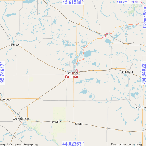
Willmar GPS coordinates[2]
45° 7' 18.876" North, 95° 2' 36.024" West
| Map corner | latitude | longitude |
|---|---|---|
| Upper-left | 45.61588°, | -95.74647° |
| Center: | 45.12191°, | -95.04334° |
| Lower-right: | 44.62363°, | -94.34022° |
| Map W x H: | 110.3×110.3 km | = 68.5×68.5mi |
| max Lat: | 71.29058° ⇑7% North |
| Willmar: | 45.12191° |
| min Lat: | ⇓93% South 19.06759° |
| min Long | Willmar | max Long |
| -171.73463° | -95.04334° | -66.98998° |
| W 28.8%⇐ | ⇒71.2% E |
Elevation
Elevation of Willmar is 349 m = 1145 ft, and this is 54.2 m = 178 ft above average elevation for this country.
| Max E: |
3189 m = 10463 ft | 20.4% |
| Willmar | 349 m 1145 ft | |
| Avg. | 294.8 m = 967 ft | |
Min E: |
-60 m = -197 ft | 79.6% |
See also: United States elevation on elevation.city.
Geographical zone
Willmar is located in North temperate zone (between Tropic of Cancer and the Arctic Circle). Distance of this North polar circle is 2384.1 km =1481.4 mi to North.| Distance of | km | miles | from Willmar |
|---|---|---|---|
| North Pole | 4990 | 3100.6 | to North |
| Arctic Circle | 2384.1 | 1481.4 | to North |
| Tropic Cancer | 2411.2 | 1498.2 | to South |
| Equator | 5017.1 | 3117.5 | to South |


Nearby cities:
15 places around Willmar: (largest is in red/bold)
• Atwater
20.9 km =13 mi,  84°
84°
• Belgrade
36.9 km =22.9 mi,  4°
4°
• Bird Island
41.1 km =25.5 mi,  163°
163°
• Brooten
42.6 km =26.5 mi,  351°
351°
• Clara City
31.4 km =19.5 mi,  233°
233°
• Grove City
28.4 km =17.6 mi, 83°
• Kerkhoven
23.1 km =14.4 mi,  289°
289°
• Litchfield
40.4 km =25.1 mi,  89°
89°
• New London
21.4 km =13.3 mi,  21°
21°
• Olivia
38.7 km =24 mi,  173°
173°
• Paynesville
38.7 km =24 mi,  42°
42°
• Pennock
10.9 km =6.8 mi, 286°
• Raymond
19.3 km =12 mi, 232°
• Renville
39.3 km =24.4 mi,  199°
199°
• Spicer
14.8 km =9.2 mi,  33°
33°
Sources, notices
• [Note1] Compared only with cities in United States existing in our database
• [Src1] Map data: © OpenStreetMap contributors (CC-BY-SA)
• [Src2] Other city data from geonames.org with taken over terms of usage.
• [Src3] Geographical zone / Annual Mean Temperature by Robert A. Rohde @ Wikipedia
