Spring Park geodata
Spring Park (Minnesota) is a populated place; located in United States in America/Chicago (GMT-5) time zone. With population of 1,705 people, there are 12893 cities with bigger population in this country. Compared to other cities in United States, 92.3% of cities are located further ↓South; 67.8% of cities are located further →East and 70.6% of cities have lower elevation than Spring Park. Note1
Administrative division(s):
- Level 1: Minnesota
- Level 2: Hennepin County
- Level 3: City of Spring Park


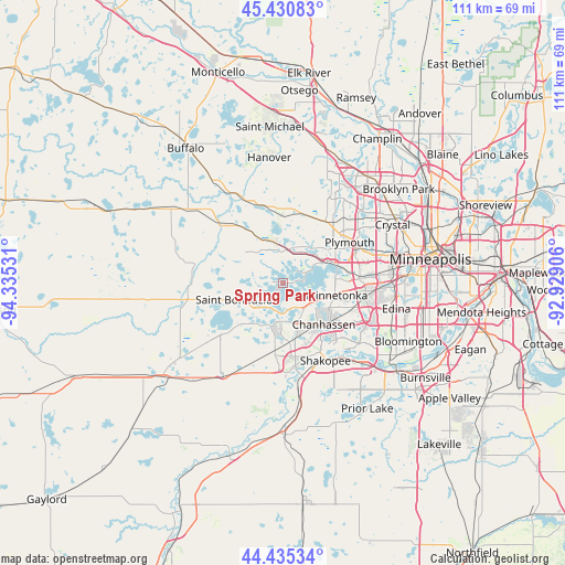
Spring Park GPS coordinates[2]
44° 56' 6.864" North, 93° 37' 55.848" West
| Map corner | latitude | longitude |
|---|---|---|
| Upper-left | 45.43083°, | -94.33531° |
| Center: | 44.93524°, | -93.63218° |
| Lower-right: | 44.43534°, | -92.92906° |
| Map W x H: | 110.7×110.7 km | = 68.8×68.8mi |
| max Lat: | 71.29058° ⇑7.7% North |
| Spring Park: | 44.93524° |
| min Lat: | ⇓92.3% South 19.06759° |
| min Long | Spring Park | max Long |
| -171.73463° | -93.63218° | -66.98998° |
| W 32.2%⇐ | ⇒67.8% E |
Elevation
Elevation of Spring Park is 289 m = 948 ft, and this is 5.8 m = 19 ft below average elevation for this country.
| Max E: |
3189 m = 10463 ft | 29.4% |
| Avg. | 294.8 m = 967 ft | |
| Spring Park | 289 m = 948 ft | |
Min E: |
-60 m = -197 ft | 70.6% |
See also: United States elevation on elevation.city.
Geographical zone
Spring Park is located in North temperate zone (between Tropic of Cancer and the Arctic Circle). Distance of this Northern Tropic circle is 2390.4 km =1485.3 mi to South.| Distance of | km | miles | from Spring Park |
|---|---|---|---|
| North Pole | 5010.7 | 3113.5 | to North |
| Arctic Circle | 2404.8 | 1494.3 | to North |
| Tropic Cancer | 2390.4 | 1485.3 | to South |
| Equator | 4996.3 | 3104.6 | to South |


Nearby cities:
15 places around Spring Park: (largest is in red/bold)
• Deephaven
8.7 km =5.4 mi,  94°
94°
• Excelsior
6.3 km =3.9 mi,  124°
124°
• Greenwood
6.6 km =4.1 mi,  109°
109°
• Long Lake
7.4 km =4.6 mi,  39°
39°
• Maple Plain
8.2 km =5.1 mi,  346°
346°
• Minnetonka
10.4 km =6.5 mi,  103°
103°
• Minnetonka Beach
4.4 km =2.7 mi,  83°
83°
• Minnetrista
6.7 km =4.2 mi,  272°
272°
• Mound
2.7 km =1.7 mi, 273°
• Orono
4.6 km =2.9 mi,  28°
28°
• Saint Bonifacius
9.7 km =6 mi,  249°
249°
• Shorewood
5.1 km =3.2 mi,  138°
138°
• Tonka Bay
4.3 km =2.7 mi,  133°
133°
• Victoria
8.8 km =5.5 mi,  195°
195°
• Wayzata
10.8 km =6.7 mi,  66°
66°
Sources, notices
• [Note1] Compared only with cities in United States existing in our database
• [Src1] Map data: © OpenStreetMap contributors (CC-BY-SA)
• [Src2] Other city data from geonames.org with taken over terms of usage.
• [Src3] Geographical zone / Annual Mean Temperature by Robert A. Rohde @ Wikipedia
