Minnetonka geodata
Minnetonka (Minnesota) is a populated place; located in United States in America/Chicago (GMT-5) time zone. With population of 51,669 people, there are 916 cities with bigger population in this country. Compared to other cities in United States, 92.2% of cities are located further ↓South; 67.5% of cities are located further →East and 67.2% of cities have lower elevation than Minnetonka. Note1


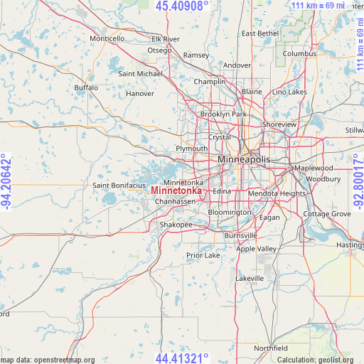
Minnetonka GPS coordinates[2]
44° 54' 47.88" North, 93° 30' 11.844" West
| Map corner | latitude | longitude |
|---|---|---|
| Upper-left | 45.40908°, | -94.20642° |
| Center: | 44.9133°, | -93.50329° |
| Lower-right: | 44.41321°, | -92.80017° |
| Map W x H: | 110.7×110.7 km | = 68.8×68.8mi |
| max Lat: | 71.29058° ⇑7.8% North |
| Minnetonka: | 44.9133° |
| min Lat: | ⇓92.2% South 19.06759° |
| min Long | Minnetonka | max Long |
| -171.73463° | -93.50329° | -66.98998° |
| W 32.5%⇐ | ⇒67.5% E |
Elevation
Elevation of Minnetonka is 272 m = 892 ft, and this is 22.8 m = 75 ft below average elevation for this country.
| Max E: |
3189 m = 10463 ft | 32.8% |
| Avg. | 294.8 m = 967 ft | |
| Minnetonka | 272 m = 892 ft | |
Min E: |
-60 m = -197 ft | 67.2% |
See also: Minnetonka elevation on elevation.city.
Geographical zone
Minnetonka is located in North temperate zone (between Tropic of Cancer and the Arctic Circle). Distance of this Northern Tropic circle is 2388 km =1483.8 mi to South.| Distance of | km | miles | from Minnetonka |
|---|---|---|---|
| North Pole | 5013.2 | 3115.1 | to North |
| Arctic Circle | 2407.3 | 1495.8 | to North |
| Tropic Cancer | 2388 | 1483.8 | to South |
| Equator | 4993.9 | 3103.1 | to South |


Nearby cities:
15 places around Minnetonka: (largest is in red/bold)
• Chanhassen
6.1 km =3.8 mi,  200°
200°
• Deephaven
2.4 km =1.5 mi,  320°
320°
• Eden Prairie
7 km =4.3 mi,  158°
158°
• Excelsior
5.1 km =3.2 mi,  257°
257°
• Greenwood
3.9 km =2.4 mi,  272°
272°
• Hopkins
3.4 km =2.1 mi,  67°
67°
• Long Lake
9.8 km =6.1 mi,  326°
326°
• Minnetonka Beach
6.5 km =4 mi,  296°
296°
• Minnetonka Mills
5.7 km =3.5 mi,  57°
57°
• Orono
10.2 km =6.3 mi,  309°
309°
• Plymouth
11.4 km =7.1 mi,  19°
19°
• Shorewood
6.9 km =4.3 mi, 258°
• Spring Park
10.4 km =6.5 mi,  283°
283°
• Tonka Bay
7.1 km =4.4 mi, 265°
• Wayzata
6.8 km =4.2 mi,  357°
357°
Sources, notices
• [Note1] Compared only with cities in United States existing in our database
• [Src1] Map data: © OpenStreetMap contributors (CC-BY-SA)
• [Src2] Other city data from geonames.org with taken over terms of usage.
• [Src3] Geographical zone / Annual Mean Temperature by Robert A. Rohde @ Wikipedia
