Dorchester geodata
Dorchester (Nebraska) is a populated place; located in United States in America/Chicago (GMT-5) time zone. With population of 576 people, there are 19960 cities with bigger population in this country. Compared to other cities in United States, 60.8% of cities are located further ↓South; 76% of cities are located further →East and 86.5% of cities have lower elevation than Dorchester. Note1


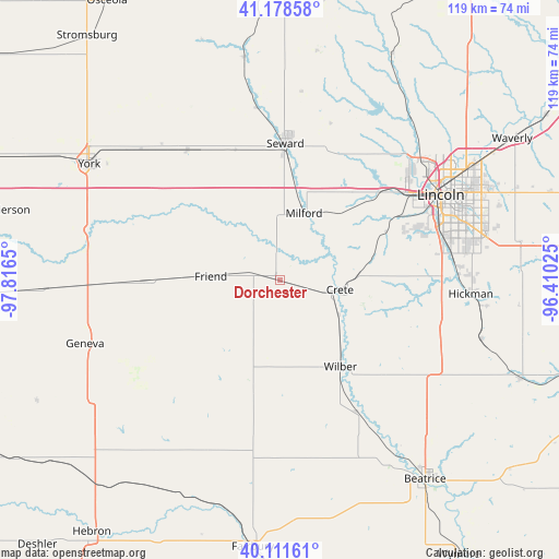
Dorchester GPS coordinates[2]
40° 38' 50.028" North, 97° 6' 48.132" West
| Map corner | latitude | longitude |
|---|---|---|
| Upper-left | 41.17858°, | -97.8165° |
| Center: | 40.64723°, | -97.11337° |
| Lower-right: | 40.11161°, | -96.41025° |
| Map W x H: | 118.6×118.6 km | = 73.7×73.7mi |
| max Lat: | 71.29058° ⇑39.2% North |
| Dorchester: | 40.64723° |
| min Lat: | ⇓60.8% South 19.06759° |
| min Long | Dorchester | max Long |
| -171.73463° | -97.11337° | -66.98998° |
| W 24%⇐ | ⇒76% E |
Elevation
Elevation of Dorchester is 454 m = 1490 ft, and this is 159.2 m = 522 ft above average elevation for this country.
| Max E: |
3189 m = 10463 ft | 13.5% |
| Dorchester | 454 m 1490 ft | |
| Avg. | 294.8 m = 967 ft | |
Min E: |
-60 m = -197 ft | 86.5% |
See also: United States elevation on elevation.city.
Geographical zone
Dorchester is located in North temperate zone (between Tropic of Cancer and the Arctic Circle). Distance of this Northern Tropic circle is 1913.6 km =1189.1 mi to South.| Distance of | km | miles | from Dorchester |
|---|---|---|---|
| North Pole | 5487.5 | 3409.8 | to North |
| Arctic Circle | 2881.6 | 1790.5 | to North |
| Tropic Cancer | 1913.6 | 1189.1 | to South |
| Equator | 4519.5 | 2808.3 | to South |


Nearby cities:
15 places around Dorchester: (largest is in red/bold)
• Bennet
51.3 km =31.9 mi,  85°
85°
• Crete
13 km =8.1 mi,  99°
99°
• De Witt
32.5 km =20.2 mi,  150°
150°
• Exeter
28.4 km =17.6 mi,  269°
269°
• Fairmont
39.8 km =24.7 mi, 268°
• Firth
44.7 km =27.8 mi,  106°
106°
• Friend
14.6 km =9.1 mi, 272°
• Geneva
42.9 km =26.7 mi,  251°
251°
• Hickman
41 km =25.5 mi, 94°
• Lincoln
41.3 km =25.7 mi,  65°
65°
• Milford
15.1 km =9.4 mi,  20°
20°
• Seward
28.9 km =18 mi,  2°
2°
• Utica
33.9 km =21.1 mi,  324°
324°
• Wilber
22.5 km =14 mi, 145°
• York
47.2 km =29.3 mi,  301°
301°
Sources, notices
• [Note1] Compared only with cities in United States existing in our database
• [Src1] Map data: © OpenStreetMap contributors (CC-BY-SA)
• [Src2] Other city data from geonames.org with taken over terms of usage.
• [Src3] Geographical zone / Annual Mean Temperature by Robert A. Rohde @ Wikipedia
