Exeter geodata
Exeter (Nebraska) is a populated place; located in United States in America/Chicago (GMT-5) time zone. With population of 538 people, there are 20410 cities with bigger population in this country. Compared to other cities in United States, 60.7% of cities are located further ↓South; 77% of cities are located further →East and 87.6% of cities have lower elevation than Exeter. Note1
Administrative division(s):
- Level 1: Nebraska
- Level 2: Fillmore County
- Level 3: Township of Exeter-Fairmont Consolidated


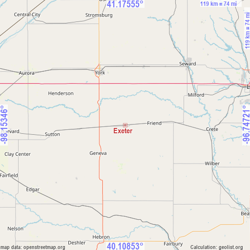
Exeter GPS coordinates[2]
40° 38' 39.012" North, 97° 27' 1.188" West
| Map corner | latitude | longitude |
|---|---|---|
| Upper-left | 41.17555°, | -98.15346° |
| Center: | 40.64417°, | -97.45033° |
| Lower-right: | 40.10853°, | -96.74721° |
| Map W x H: | 118.6×118.6 km | = 73.7×73.7mi |
| max Lat: | 71.29058° ⇑39.3% North |
| Exeter: | 40.64417° |
| min Lat: | ⇓60.7% South 19.06759° |
| min Long | Exeter | max Long |
| -171.73463° | -97.45033° | -66.98998° |
| W 23%⇐ | ⇒77% E |
Elevation
Elevation of Exeter is 491 m = 1611 ft, and this is 196.2 m = 644 ft above average elevation for this country.
| Max E: |
3189 m = 10463 ft | 12.4% |
| Exeter | 491 m 1611 ft | |
| Avg. | 294.8 m = 967 ft | |
Min E: |
-60 m = -197 ft | 87.6% |
See also: United States elevation on elevation.city.
Geographical zone
Exeter is located in North temperate zone (between Tropic of Cancer and the Arctic Circle). Distance of this Northern Tropic circle is 1913.3 km =1188.9 mi to South.| Distance of | km | miles | from Exeter |
|---|---|---|---|
| North Pole | 5487.9 | 3410 | to North |
| Arctic Circle | 2882 | 1790.8 | to North |
| Tropic Cancer | 1913.3 | 1188.9 | to South |
| Equator | 4519.2 | 2808.1 | to South |


Nearby cities:
15 places around Exeter: (largest is in red/bold)
• Aurora
52.8 km =32.8 mi,  297°
297°
• Clay Center
52.9 km =32.9 mi,  255°
255°
• Crete
41.3 km =25.7 mi,  92°
92°
• De Witt
52.6 km =32.7 mi,  121°
121°
• Dorchester
28.4 km =17.6 mi, 89°
• Fairmont
11.4 km =7.1 mi,  265°
265°
• Friend
13.9 km =8.6 mi, 85°
• Geneva
17.9 km =11.1 mi,  223°
223°
• Henderson
34 km =21.1 mi, 296°
• Milford
36.7 km =22.8 mi,  66°
66°
• Seward
41.6 km =25.8 mi,  45°
45°
• Sutton
34.8 km =21.6 mi, 262°
• Utica
29.4 km =18.3 mi,  17°
17°
• Wilber
45.2 km =28.1 mi,  113°
113°
• York
27.6 km =17.1 mi,  334°
334°
Sources, notices
• [Note1] Compared only with cities in United States existing in our database
• [Src1] Map data: © OpenStreetMap contributors (CC-BY-SA)
• [Src2] Other city data from geonames.org with taken over terms of usage.
• [Src3] Geographical zone / Annual Mean Temperature by Robert A. Rohde @ Wikipedia
