O'Neill geodata
O'Neill (Nebraska) is a seat of a second-order administrative division; located in United States in America/Chicago (GMT-5) time zone. With population of 3,653 people, there are 8653 cities with bigger population in this country. Compared to other cities in United States, 79.4% of cities are located further ↓South; 79.6% of cities are located further →East and 89.8% of cities have lower elevation than O'Neill. Note1


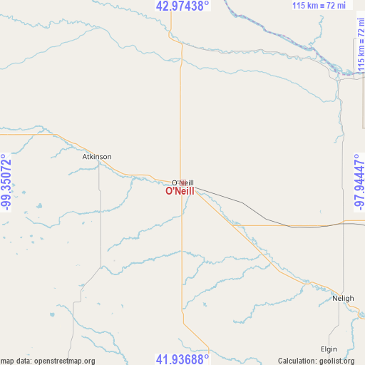
O'Neill GPS coordinates[2]
42° 27' 28.008" North, 98° 38' 51.324" West
| Map corner | latitude | longitude |
|---|---|---|
| Upper-left | 42.97438°, | -99.35072° |
| Center: | 42.45778°, | -98.64759° |
| Lower-right: | 41.93688°, | -97.94447° |
| Map W x H: | 115.4×115.4 km | = 71.7×71.7mi |
| max Lat: | 71.29058° ⇑20.6% North |
| O'Neill: | 42.45778° |
| min Lat: | ⇓79.4% South 19.06759° |
| min Long | O'Neill | max Long |
| -171.73463° | -98.64759° | -66.98998° |
| W 20.4%⇐ | ⇒79.6% E |
Elevation
Elevation of O'Neill is 608 m = 1995 ft, and this is 313.2 m = 1028 ft above average elevation for this country.
| Max E: |
3189 m = 10463 ft | 10.2% |
| O'Neill | 608 m 1995 ft | |
| Avg. | 294.8 m = 967 ft | |
Min E: |
-60 m = -197 ft | 89.8% |
See also: United States elevation on elevation.city.
Geographical zone
O'Neill is located in North temperate zone (between Tropic of Cancer and the Arctic Circle). Distance of this Northern Tropic circle is 2114.9 km =1314.1 mi to South.| Distance of | km | miles | from O'Neill |
|---|---|---|---|
| North Pole | 5286.2 | 3284.7 | to North |
| Arctic Circle | 2680.3 | 1665.5 | to North |
| Tropic Cancer | 2114.9 | 1314.1 | to South |
| Equator | 4720.9 | 2933.4 | to South |


Nearby cities:
15 places around O'Neill: (largest is in red/bold)
• Atkinson
28.3 km =17.6 mi,  286°
286°
• Avon
77.5 km =48.2 mi,  38°
38°
• Bartlett
64.1 km =39.8 mi,  172°
172°
• Bassett
74.3 km =46.2 mi,  281°
281°
• Butte
53.1 km =33 mi,  341°
341°
• Center
65.4 km =40.6 mi,  75°
75°
• Creighton
60.8 km =37.8 mi,  89°
89°
• Elgin
70.3 km =43.7 mi,  138°
138°
• Lake Andes
78.2 km =48.6 mi,  6°
6°
• Neligh
62.6 km =38.9 mi,  125°
125°
• Plainview
71.3 km =44.3 mi,  99°
99°
• Springfield
75.5 km =46.9 mi,  54°
54°
• Stuart
43.5 km =27 mi, 291°
• Verdigre
52.6 km =32.7 mi,  72°
72°
• Wagner
75 km =46.6 mi,  22°
22°
Sources, notices
• [Note1] Compared only with cities in United States existing in our database
• [Src1] Map data: © OpenStreetMap contributors (CC-BY-SA)
• [Src2] Other city data from geonames.org with taken over terms of usage.
• [Src3] Geographical zone / Annual Mean Temperature by Robert A. Rohde @ Wikipedia
