Bartlett geodata
Bartlett (Nebraska) is a seat of a second-order administrative division; located in United States in America/Chicago (GMT-5) time zone. With population of 109 people, there are 21036 cities with bigger population in this country. Compared to other cities in United States, 74.6% of cities are located further ↓South; 79.4% of cities are located further →East and 90.6% of cities have lower elevation than Bartlett. Note1


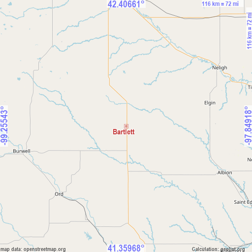
Bartlett GPS coordinates[2]
41° 53' 7.044" North, 98° 33' 8.28" West
| Map corner | latitude | longitude |
|---|---|---|
| Upper-left | 42.40661°, | -99.25543° |
| Center: | 41.88529°, | -98.5523° |
| Lower-right: | 41.35968°, | -97.84918° |
| Map W x H: | 116.4×116.4 km | = 72.3×72.3mi |
| max Lat: | 71.29058° ⇑25.4% North |
| Bartlett: | 41.88529° |
| min Lat: | ⇓74.6% South 19.06759° |
| min Long | Bartlett | max Long |
| -171.73463° | -98.5523° | -66.98998° |
| W 20.6%⇐ | ⇒79.4% E |
Elevation
Elevation of Bartlett is 669 m = 2195 ft, and this is 374.2 m = 1228 ft above average elevation for this country.
| Max E: |
3189 m = 10463 ft | 9.4% |
| Bartlett | 669 m 2195 ft | |
| Avg. | 294.8 m = 967 ft | |
Min E: |
-60 m = -197 ft | 90.6% |
See also: United States elevation on elevation.city.
Geographical zone
Bartlett is located in North temperate zone (between Tropic of Cancer and the Arctic Circle). Distance of this Northern Tropic circle is 2051.3 km =1274.6 mi to South.| Distance of | km | miles | from Bartlett |
|---|---|---|---|
| North Pole | 5349.9 | 3324.3 | to North |
| Arctic Circle | 2744 | 1705 | to North |
| Tropic Cancer | 2051.3 | 1274.6 | to South |
| Equator | 4657.2 | 2893.8 | to South |


Nearby cities:
15 places around Bartlett: (largest is in red/bold)
• Albion
50.4 km =31.3 mi,  115°
115°
• Burwell
49.5 km =30.8 mi,  256°
256°
• Elgin
40.3 km =25 mi,  74°
74°
• Fullerton
75.6 km =47 mi,  140°
140°
• Greeley
37.5 km =23.3 mi,  177°
177°
• Loup City
76.1 km =47.3 mi,  206°
206°
• Neligh
50.9 km =31.6 mi,  57°
57°
• Newman Grove
66.1 km =41.1 mi,  103°
103°
• O'Neill
64.1 km =39.8 mi,  352°
352°
• Ord
44.1 km =27.4 mi,  224°
224°
• Saint Edward
66.9 km =41.6 mi, 121°
• Saint Paul
75 km =46.6 mi,  173°
173°
• Sargent
73.2 km =45.5 mi,  248°
248°
• Taylor
69.7 km =43.3 mi, 259°
• Tilden
62.1 km =38.6 mi, 73°
Sources, notices
• [Note1] Compared only with cities in United States existing in our database
• [Src1] Map data: © OpenStreetMap contributors (CC-BY-SA)
• [Src2] Other city data from geonames.org with taken over terms of usage.
• [Src3] Geographical zone / Annual Mean Temperature by Robert A. Rohde @ Wikipedia
