Winnebago geodata
Winnebago (Nebraska) is a populated place; located in United States in America/Chicago (GMT-5) time zone. With population of 787 people, there are 17933 cities with bigger population in this country. Compared to other cities in United States, 77.6% of cities are located further ↓South; 74.4% of cities are located further →East and 80% of cities have lower elevation than Winnebago. Note1
Administrative division(s):
- Level 1: Nebraska
- Level 2: Thurston County
- Level 3: Township of Winnebago


Winnebago GPS coordinates[2]
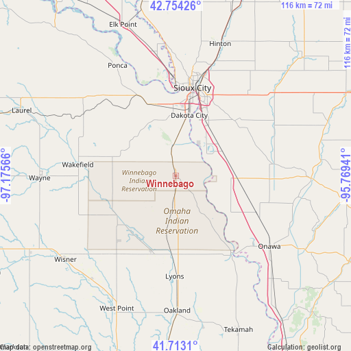
42° 14' 8.988" North, 96° 28' 21.108" West
| Map corner | latitude | longitude |
|---|---|---|
| Upper-left | 42.75426°, | -97.17566° |
| Center: | 42.23583°, | -96.47253° |
| Lower-right: | 41.7131°, | -95.76941° |
| Map W x H: | 115.8×115.8 km | = 72×72mi |
| max Lat: | 71.29058° ⇑22.4% North |
| Winnebago: | 42.23583° |
| min Lat: | ⇓77.6% South 19.06759° |
| min Long | Winnebago | max Long |
| -171.73463° | -96.47253° | -66.98998° |
| W 25.6%⇐ | ⇒74.4% E |
Elevation
Elevation of Winnebago is 354 m = 1161 ft, and this is 59.2 m = 194 ft above average elevation for this country.
| Max E: |
3189 m = 10463 ft | 20% |
| Winnebago | 354 m 1161 ft | |
| Avg. | 294.8 m = 967 ft | |
Min E: |
-60 m = -197 ft | 80% |
See also: United States elevation on elevation.city.
Geographical zone
Winnebago is located in North temperate zone (between Tropic of Cancer and the Arctic Circle). Distance of this Northern Tropic circle is 2090.3 km =1298.9 mi to South.| Distance of | km | miles | from Winnebago |
|---|---|---|---|
| North Pole | 5310.9 | 3300 | to North |
| Arctic Circle | 2705 | 1680.8 | to North |
| Tropic Cancer | 2090.3 | 1298.9 | to South |
| Equator | 4696.2 | 2918.1 | to South |


Nearby cities:
15 places around Winnebago: (largest is in red/bold)
• Dakota City
20.5 km =12.7 mi,  12°
12°
• Dakota Dunes
28 km =17.4 mi,  357°
357°
• Emerson
21.5 km =13.4 mi,  282°
282°
• Homer
9.6 km =6 mi,  351°
351°
• Lyons
33.2 km =20.6 mi,  180°
180°
• Macy
16.7 km =10.4 mi,  144°
144°
• North Sioux City
32.4 km =20.1 mi, 358°
• Pender
23.6 km =14.7 mi,  235°
235°
• Sergeant Bluff
20.9 km =13 mi,  26°
26°
• Sioux City
30 km =18.6 mi, 11°
• Sloan
20.1 km =12.5 mi,  90°
90°
• South Sioux City
26.9 km =16.7 mi, 10°
• Wakefield
32.5 km =20.2 mi, 276°
• Walthill
9.8 km =6.1 mi,  187°
187°
• Whiting
29.2 km =18.1 mi,  114°
114°
Sources, notices
• [Note1] Compared only with cities in United States existing in our database
• [Src1] Map data: © OpenStreetMap contributors (CC-BY-SA)
• [Src2] Other city data from geonames.org with taken over terms of usage.
• [Src3] Geographical zone / Annual Mean Temperature by Robert A. Rohde @ Wikipedia
