Whiting geodata
Whiting (Iowa) is a populated place; located in United States in America/Chicago (GMT-5) time zone. With population of 753 people, there are 18194 cities with bigger population in this country. Compared to other cities in United States, 76.8% of cities are located further ↓South; 73.7% of cities are located further →East and 76.5% of cities have lower elevation than Whiting. Note1


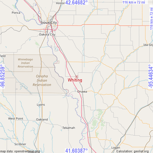
Whiting GPS coordinates[2]
42° 7' 38.964" North, 96° 8' 58.056" West
| Map corner | latitude | longitude |
|---|---|---|
| Upper-left | 42.64682°, | -96.85259° |
| Center: | 42.12749°, | -96.14946° |
| Lower-right: | 41.60387°, | -95.44634° |
| Map W x H: | 116×116 km | = 72.1×72.1mi |
| max Lat: | 71.29058° ⇑23.2% North |
| Whiting: | 42.12749° |
| min Lat: | ⇓76.8% South 19.06759° |
| min Long | Whiting | max Long |
| -171.73463° | -96.14946° | -66.98998° |
| W 26.3%⇐ | ⇒73.7% E |
Elevation
Elevation of Whiting is 324 m = 1063 ft, and this is 29.2 m = 96 ft above average elevation for this country.
| Max E: |
3189 m = 10463 ft | 23.5% |
| Whiting | 324 m 1063 ft | |
| Avg. | 294.8 m = 967 ft | |
Min E: |
-60 m = -197 ft | 76.5% |
See also: United States elevation on elevation.city.
Geographical zone
Whiting is located in North temperate zone (between Tropic of Cancer and the Arctic Circle). Distance of this Northern Tropic circle is 2078.2 km =1291.3 mi to South.| Distance of | km | miles | from Whiting |
|---|---|---|---|
| North Pole | 5322.9 | 3307.5 | to North |
| Arctic Circle | 2717 | 1688.3 | to North |
| Tropic Cancer | 2078.2 | 1291.3 | to South |
| Equator | 4684.1 | 2910.6 | to South |


Nearby cities:
15 places around Whiting: (largest is in red/bold)
• Anthon
37.2 km =23.1 mi,  38°
38°
• Dakota City
38.9 km =24.2 mi,  325°
325°
• Homer
35.4 km =22 mi,  307°
307°
• Lawton
39.1 km =24.3 mi,  355°
355°
• Lyons
34.3 km =21.3 mi,  232°
232°
• Macy
17.1 km =10.6 mi,  264°
264°
• Mapleton
29.7 km =18.5 mi,  81°
81°
• Moville
40.7 km =25.3 mi,  8°
8°
• Oakland
41.7 km =25.9 mi,  218°
218°
• Onawa
12 km =7.5 mi,  158°
158°
• Sergeant Bluff
35.2 km =21.9 mi, 330°
• Sloan
13.4 km =8.3 mi, 331°
• Tekamah
39.3 km =24.4 mi,  188°
188°
• Walthill
28 km =17.4 mi,  274°
274°
• Winnebago
29.2 km =18.1 mi,  294°
294°
Sources, notices
• [Note1] Compared only with cities in United States existing in our database
• [Src1] Map data: © OpenStreetMap contributors (CC-BY-SA)
• [Src2] Other city data from geonames.org with taken over terms of usage.
• [Src3] Geographical zone / Annual Mean Temperature by Robert A. Rohde @ Wikipedia
