Concord geodata
Concord (New Hampshire) is a seat of a first-order administrative division; located in United States in America/New_York (GMT-4) time zone. With population of 42,620 people, there are 1125 cities with bigger population in this country. Compared to other cities in United States, 84.8% of cities are located further ↓South; 96.5% of cities are located further ←West and 72.3% of cities have higher elevation than Concord. Note1
Administrative division(s):
- Level 1: New Hampshire
- Level 2: Merrimack County
- Level 3: City of Concord


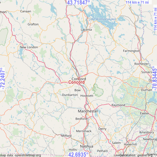
Concord GPS coordinates[2]
43° 12' 29.304" North, 71° 32' 15.252" West
| Map corner | latitude | longitude |
|---|---|---|
| Upper-left | 43.71847°, | -72.2407° |
| Center: | 43.20814°, | -71.53757° |
| Lower-right: | 42.6935°, | -70.83445° |
| Map W x H: | 114×114 km | = 70.8×70.8mi |
| max Lat: | 71.29058° ⇑15.2% North |
| Concord: | 43.20814° |
| min Lat: | ⇓84.8% South 19.06759° |
| min Long | Concord | max Long |
| -171.73463° | -71.53757° | -66.98998° |
| W 96.5%⇐ | ⇒3.5% E |
Elevation
Elevation of Concord is 87 m = 285 ft, and this is 207.8 m = 682 ft below average elevation for this country.
| Max E: |
3189 m = 10463 ft | 72.3% |
| Avg. | 294.8 m = 967 ft | |
| Concord | 87 m = 285 ft | |
Min E: |
-60 m = -197 ft | 27.7% |
See also: Concord elevation on elevation.city.
Geographical zone
Concord is located in North temperate zone (between Tropic of Cancer and the Arctic Circle). Distance of this Northern Tropic circle is 2198.4 km =1366 mi to South.| Distance of | km | miles | from Concord |
|---|---|---|---|
| North Pole | 5202.8 | 3232.9 | to North |
| Arctic Circle | 2596.9 | 1613.6 | to North |
| Tropic Cancer | 2198.4 | 1366 | to South |
| Equator | 4804.3 | 2985.3 | to South |


Nearby cities:
15 places around Concord: (largest is in red/bold)
• Allenstown
12.2 km =7.6 mi,  117°
117°
• Boscawen
13.7 km =8.5 mi,  330°
330°
• Bow Bog
10 km =6.2 mi,  167°
167°
• Canterbury
14.5 km =9 mi,  351°
351°
• Chichester
12.1 km =7.5 mi,  67°
67°
• Contoocook
14.4 km =8.9 mi,  276°
276°
• East Concord
3.8 km =2.4 mi,  359°
359°
• Epsom
16.7 km =10.4 mi,  84°
84°
• Hooksett
13.7 km =8.5 mi,  154°
154°
• Hopkinton
11.3 km =7 mi,  260°
260°
• Loudon
10.3 km =6.4 mi,  33°
33°
• Pembroke
9.4 km =5.8 mi,  136°
136°
• Suncook
11 km =6.8 mi, 141°
• Weare
20.1 km =12.5 mi,  231°
231°
• Webster
19.8 km =12.3 mi,  312°
312°
Sources, notices
• [Note1] Compared only with cities in United States existing in our database
• [Src1] Map data: © OpenStreetMap contributors (CC-BY-SA)
• [Src2] Other city data from geonames.org with taken over terms of usage.
• [Src3] Geographical zone / Annual Mean Temperature by Robert A. Rohde @ Wikipedia
