Weare geodata
Weare (New Hampshire) is a populated place; located in United States in America/New_York (GMT-4) time zone. With population of 8,583 people, there are 4980 cities with bigger population in this country. Compared to other cities in United States, 84.1% of cities are located further ↓South; 96.1% of cities are located further ←West and 51.1% of cities have higher elevation than Weare. Note1
Administrative division(s):
- Level 1: New Hampshire
- Level 2: Hillsborough County
- Level 3: Town of Weare


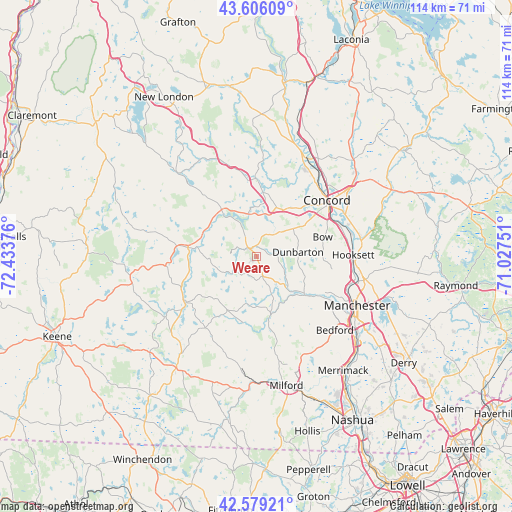
Weare GPS coordinates[2]
43° 5' 41.28" North, 71° 43' 50.268" West
| Map corner | latitude | longitude |
|---|---|---|
| Upper-left | 43.60609°, | -72.43376° |
| Center: | 43.0948°, | -71.73063° |
| Lower-right: | 42.57921°, | -71.02751° |
| Map W x H: | 114.2×114.2 km | = 71×71mi |
| max Lat: | 71.29058° ⇑15.9% North |
| Weare: | 43.0948° |
| min Lat: | ⇓84.1% South 19.06759° |
| min Long | Weare | max Long |
| -171.73463° | -71.73063° | -66.98998° |
| W 96.1%⇐ | ⇒3.9% E |
Elevation
Elevation of Weare is 194 m = 636 ft, and this is 100.8 m = 331 ft below average elevation for this country.
| Max E: |
3189 m = 10463 ft | 51.1% |
| Avg. | 294.8 m = 967 ft | |
| Weare | 194 m = 636 ft | |
Min E: |
-60 m = -197 ft | 48.9% |
See also: United States elevation on elevation.city.
Geographical zone
Weare is located in North temperate zone (between Tropic of Cancer and the Arctic Circle). Distance of this Northern Tropic circle is 2185.8 km =1358.2 mi to South.| Distance of | km | miles | from Weare |
|---|---|---|---|
| North Pole | 5215.4 | 3240.7 | to North |
| Arctic Circle | 2609.5 | 1621.5 | to North |
| Tropic Cancer | 2185.8 | 1358.2 | to South |
| Equator | 4791.7 | 2977.4 | to South |


Nearby cities:
15 places around Weare: (largest is in red/bold)
• Antrim
18.4 km =11.4 mi,  247°
247°
• Bow Bog
18 km =11.2 mi,  80°
80°
• Concord
20.1 km =12.5 mi,  51°
51°
• Contoocook
14.2 km =8.8 mi,  5°
5°
• Deering
9.6 km =6 mi,  255°
255°
• Francestown
13.7 km =8.5 mi,  209°
209°
• Goffstown
13.4 km =8.3 mi,  128°
128°
• Greenfield
19.7 km =12.2 mi,  215°
215°
• Henniker
12 km =7.5 mi,  321°
321°
• Hillsborough
13.9 km =8.6 mi,  278°
278°
• Hooksett
21.6 km =13.4 mi,  89°
89°
• Hopkinton
11.6 km =7.2 mi,  22°
22°
• Lyndeborough
21 km =13 mi,  187°
187°
• New Boston
13.5 km =8.4 mi,  167°
167°
• Pinardville
21.3 km =13.2 mi,  121°
121°
Sources, notices
• [Note1] Compared only with cities in United States existing in our database
• [Src1] Map data: © OpenStreetMap contributors (CC-BY-SA)
• [Src2] Other city data from geonames.org with taken over terms of usage.
• [Src3] Geographical zone / Annual Mean Temperature by Robert A. Rohde @ Wikipedia
